Weather Blog: Time To Think Spring (Flooding)
Allow me, if you will, to speak for just about everyone who has emailed me in the past month: we're ready for spring! At this point in February, of course, spring isn't ready for us... but it is time to start thinking about the spring flood season.
Official flood forecasts for our area are issued by the North Central River Forecast Center, a division of NOAA's National Weather Service. At this time of year--when the ground is still frozen and flooding is a few months away--updates are issued monthly; weekly or daily updates begin when water starts to flow, usually in March or April.
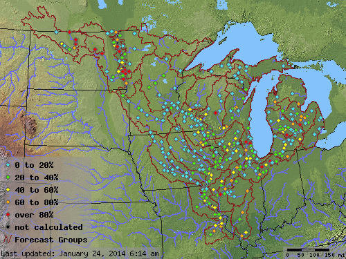
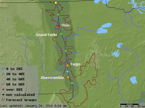
The latest regional flood forecast (pictured above) shows that at least minor flooding is likely throughout the Red River valley, with flooding also likely along parts of the Mississippi. Focusing on the Red River valley (pictured below) reveals that there's a greater than 50/50 chance of moderate to major flooding at Oslo, Fargo and Abercrombie.
These forecasts, of course, will change with time, and an updated forecast is due out at the end of February. In the meantime, hydrologists (who study how the earth's water system works) and meteorologists will keep tabs on the amount of additional snowfall we receive, rainfall, how fast springtime melting occurs, and any large chunks of river ice that break free that could cause ice jams.
One thing is certain: in our area the prospects for springtime flooding this year are greater than the past 2 years. We can say that with confidence for a few reasons, including:
(1) Drought conditions have improved and, while that's generally a good thing, it does mean that the soil will be unable to absorb as much snowmelt and runoff as it did last year. A year ago, in February 2013, all soil in Minnesota was abnormally dry, and about 70% was experiencing a severe or extreme drought. In February 2014, there are no severe or extreme drought conditions, and only 51% of the area is dry (mostly in central and southern Minnesota).
(2) Snowfall has been above average throughout the Midwest this winter and, at least in Minnesota, is outpacing totals seen during the winters of 2011-2012 and 2012-2013. The maps below show a comparison between the snowfall for the 2013-2014 season and the 30-year climate average.
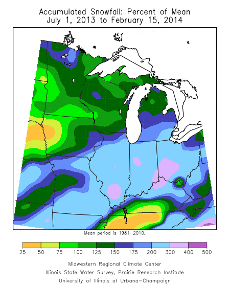
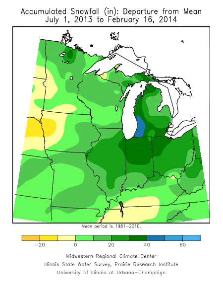
In the first map above, the blue-shaded areas in northern Minnesota and the Red River valley show where snowfall this winter has been 1.5 to 2 times greater than average. The light blue and pink shading that covers parts of Missouri, Illinois, Indiana and Ohio shows where snowfall has been 3 to 4 times greater than average. The second map shows what this means in raw numbers: an extra foot-and-a-half to 3 feet of snow above average. When it's time to melt, all of that snow has to go somewhere.
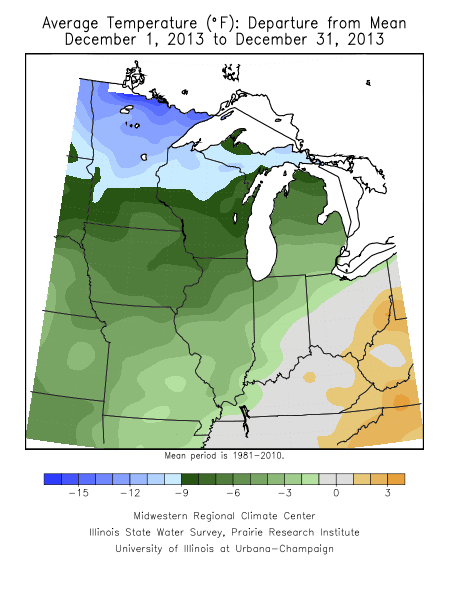
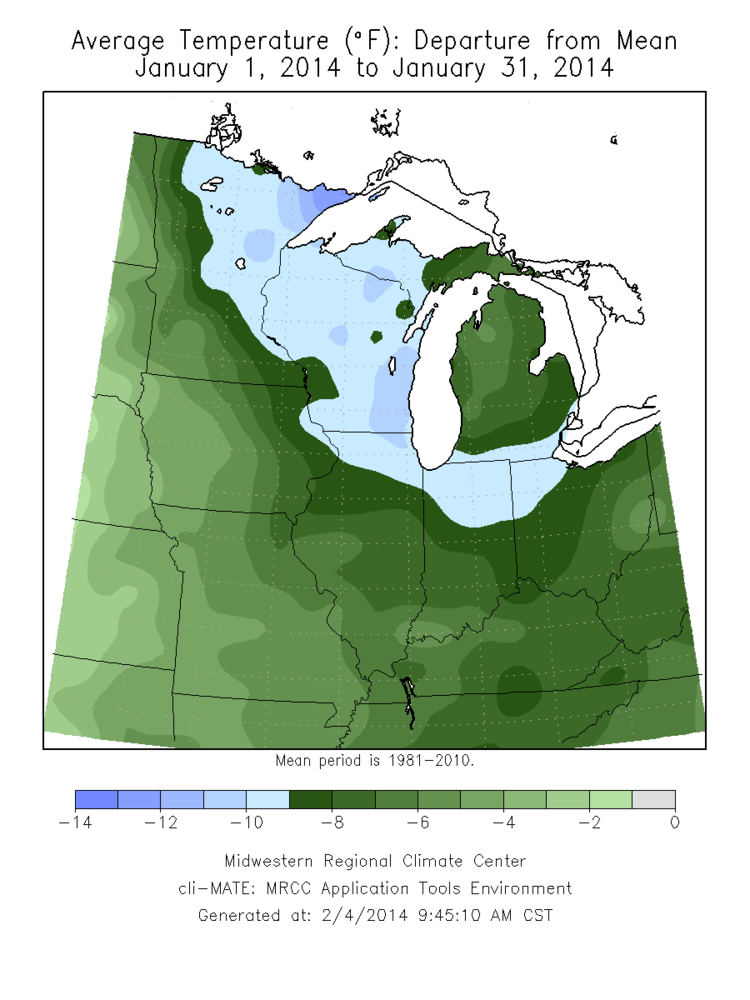
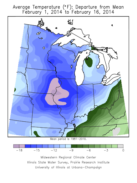
(3) It has been incredibly cold across the Midwest this winter, with temperatures running below average--by a lot--for December, January and through the first half of February. (Observe the images below to how far below average temperatures have been over the past 3 months).
This much cold, for this long, means the ground is also colder and frozen to a deeper level than in years past. When (if?) temperatures eventually warm up, the frozen ground will prevent early-season snowmelt from soaking into the soil, encouraging runoff and increasing the potential for flooding.
(4) The long-range forecast calls for more cold across the Midwest, with a continuation of the same weather pattern we have seen all winter. While this may delay the start of spring, it's difficult to interpret what impact that will have on flooding. On one hand, a colder-than-average spring could mean that accumulating snow continues through April (and into May again), adding more moisture to flood with. On the other hand, a cold spring could mean that snowmelt happens slowly enough that widespread flooding is averted.
We will learn more about how this spring flood season will play out over the next few months. In the meantime, if you live in a flood prone area, now is the time to be thinking about how you will protect your family and property when, and if, the time comes.