Weather Blog: Did This Last Winter Contradict Global Warming?
Think this past cold and snowy winter contradicts global warming? Think again …
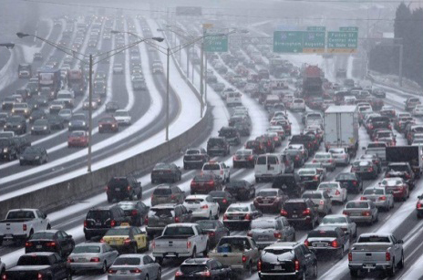
A top-ten tally of 50 days with minus-zero lows in the Twin Cities, a record 60 days of minus-zero temps in Duluth, havoc-wreaking snow and ice in the South and nearly 40 inches of above-normal snowfall in major Northeast cities including Philadelphia, New York City and Boston …

Winter 2013-2014 will forever conjure up bitter memories of extreme cold and human-dwarfing snow mounds. So how is a season which propelled the terrifying - yet meteorologically credible when used properly - term "polar vortex" into our every-day lexicon evidence of global "warming?" The answer isn't simple, but it is science.
The Explanation Is Rooted In The Arctic
The planet's northern-most region is warming at a rate two- to three-times faster than the Mid-Latitudes (where we live). This warming is largely attributed to the loss of Arctic sea-ice extent which is 75-percent less than levels observed just 30 years ago.
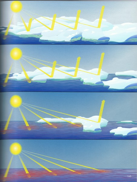
Ice retains a high "albedo," or rate of reflectivity. Consider our past winter landscape: snow everywhere. White (aka clean) snow also yields a high albedo. Its effect is witnessed on a clear day; the sunlight reflected off the vast metro snow-scape created conditions so bright and blinding that even the best Ray-Bans could not mitigate. Arctic sea ice performs the same function by reflecting sunlight, and thereby deflecting a proportion of radiational warmth back into outer space.
Worse yet for our climate system are areas of dark, open ocean which are trading places with the ice. As we know from donning a dark-colored T-shirt on a hot, sunny day and the excessive sweating that results, dark colors absorb heat. Zones in the Arctic - which in the past performed heat expulsion - now initiate heat absorption. Oceanic heat absorption is greatest in summer when the sea-ice extent is at its seasonal minimum. Come fall and winter, that warmth is then released into the Arctic atmosphere.
Now Let's Look To Newton
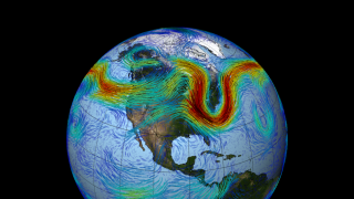
In his third Law of Motion, our good friend Isaac Newton declared: "For every action there is an equal and opposite reaction." The above-detailed rapid warming of the Arctic is yielding changes to jet stream - the fast-moving river of air positioned high in the atmosphere.
In the Northern Hemisphere, there exists two of these "rivers of air": the polar jet and the sub-tropical jet. During the winter months, the polar jet stream is top dog. It drives storm systems and serves as a boundary between cold air in the Arctic region from warmer air nearer to the Equator. Similar to a river on terra firma, the jet stream flows in waves and at varying speeds.
The speed and waviness of the jet stream is a direct result of the temperature difference between the Arctic region and that of the Mid-Latitudes. The greater the contrast, the faster and more zonal (not wavy) the jet stream will flow. The less the contrast, the slower and more meridional (wavy) the jet stream will flow.
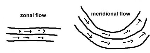
Large dips in the jet stream result when the pattern is in a wavy phase. These large dips are called "troughs." A large and deep trough allows bitter cold air from the Arctic region to plunge far south into the U.S. The unprecedented snow and ice event in Atlanta in January was a result of an atypically, deep trough.
The persistent nature of the cold, ice and snow this season is attributable to this wavy or meridional pattern, and its more frequent occurrence. When the jet stream moves in a wavy fashion it also moves more slowly, causing the weather pattern to stagnate. Thus, when the cold moves in, it very slowly moves out. Our remarkable cold in the Upper Midwest this season is a direct result of a series of deep troughs that stalled over the eastern half of the country.
To summarize, a warmer Arctic yields less temperature contrast between said region and the Mid-Latitudes. This in turn causes the jet stream to take on a slower, wavier pattern, allowing record cold to break out in the South and sub-zero cold to persist in Minnesota and neighboring states. The argument that extreme cold is evidence against global warming … is bunk.
So What Is Up With All The Snow?
Sixty-eight inches of snow fell in Philadelphia this season. That is an unbelievable 45.7-inches - or nearly 4-feet - above normal! And not only were cheese steaks served with a side of snow, New Yorkers looking for a slice of pizza pie had to traipse through 57.4 inches of city snow or over 2.5-feet above normal! And our nation's capitol ended this worse-than-Tax-Day winter with 30.8 inches of above-normal snow.
Another implication of global warming is increased water vapor or atmospheric moisture. Warmer air holds more moisture than does cold. With warmer-average global temperatures comes an increase in moisture for winter storms to utilize and produce snow.

As stated above, a more common occurrence of a wavy jet-stream pattern also yields large temperature swings. A surge of winter warmth and moisture preceding a strong cold front can set the stage for a heavy snow event.
Take for example the largest snow storm this season in Philadelphia on Jan. 21. The high temperature was 51 degrees the day before. Thirteen-point-five-inches of snow fell on the 21st and the high on the 22nd was 16 degrees. The warm air mass provided the moisture, and a large dip in the jet stream provided the cold.
More available atmospheric moisture has implications for not only winter storms but for hurricanes and heavy precipitation events or thunderstorm-produced rains, the latter of which has increased in frequency in Minnesota.
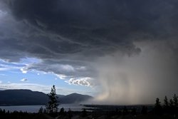
In 2012, more than several Minnesota counties were simultaneously receiving federal disaster assistance for flooding, severe weather and drought for the first time in history. This is due to the nature of thunderstorm-produced rains. One town receives an abundance of rainfall whereas another town nearby may miss out on the rain all together.
In Summary
The term 'global warming" can be a misnomer, as some may focus on the "warming," but the atmospheric and environmental implications are vast and wide reaching. They affect not only our sensible weather but, in a domino fashion, impacts pathogen and parasite populations, wintertime survival rates of insects, animal migration patterns, health of livestock, length of allergy seasons, sewer design efficiency … and so and so on …