Weather Blog: That Lake Effect, Tho!
The pictures coming out of areas just south of Buffalo, NY today are insane. There's enough snow to half-bury an NFL kicker, for Santa's Sake!
The numbers are just as incredible; this statement from the National Weather Service in Buffalo is worth a thousand pictures: "BASED ON REPORTS OF SOME AREAS FROM SOUTH BUFFALO TO LANCASTER NOW APPROACHING 50 INCHES AND THE FACT THAT THE BAND WILL NOT MOVE MUCH THROUGH LATE AFTERNOON...WE HAVE INCREASED STORM TOTALS TO AROUND 70 INCHES IN THE HARDEST HIT AREAS."
Lake effect is nothing new to the "snow belt" areas east of Lakes Erie & Ontario. The heaviest single-storm snowfall in Buffalo is the 86.1" that fell on December 24-28, 2001... but, in Buffalo's southern suburbs, this storm may surpass even that amount. An event this extreme is almost as rare as the scope of the cold we've experienced this November; in fact, the two are linked.
Today meteorologist Ryan Maue Tweeted that the over 85% of the continental U.S. woke to sub-freezing temperatures; the coldest November morning since 1976. Temperatures in the northern tier of states, like New York, have been running as much as 20°F below average. This intense blast of arctic air (that isn't the Polar Vortex) comes at a time when the Great Lakes are completely unfrozen. In fact, surface water temperatures on parts of Lake Erie are still pushing 45°F, with some warmer pockets near 50°F, a little above average at this point in the year. The combination of this open, warm water, and the arrival of arctic air, is a textbook weather setup to generate extreme lake effect snow.
The process that drives the lake effect machine is called "convection;" essentially, warm air rising. A greater temperature differential between the ground and the air (particularly in the lowest 5,000 feet of the atmosphere) generates a faster rising motion, and that leads to more intense precipitation. On a day like today the surface-to-5,000-foot temperature difference is on the order of 45°F; a difference of only 25°F is needed for lake effect precipitation to form. Such a large temperature differential has led to snowfall rates of up to 5" per hour for over 24 hours, and thunder.
The thunder is no surprise; summertime thunderstorms form through the same mechanism. In both summer and winter convection leads to localized areas of heavy precipitation, and a huge weather difference from neighborhood to neighborhood. The differences have been spectacular during this storm, as these pictures, taken at the same time about 6 miles apart, show.
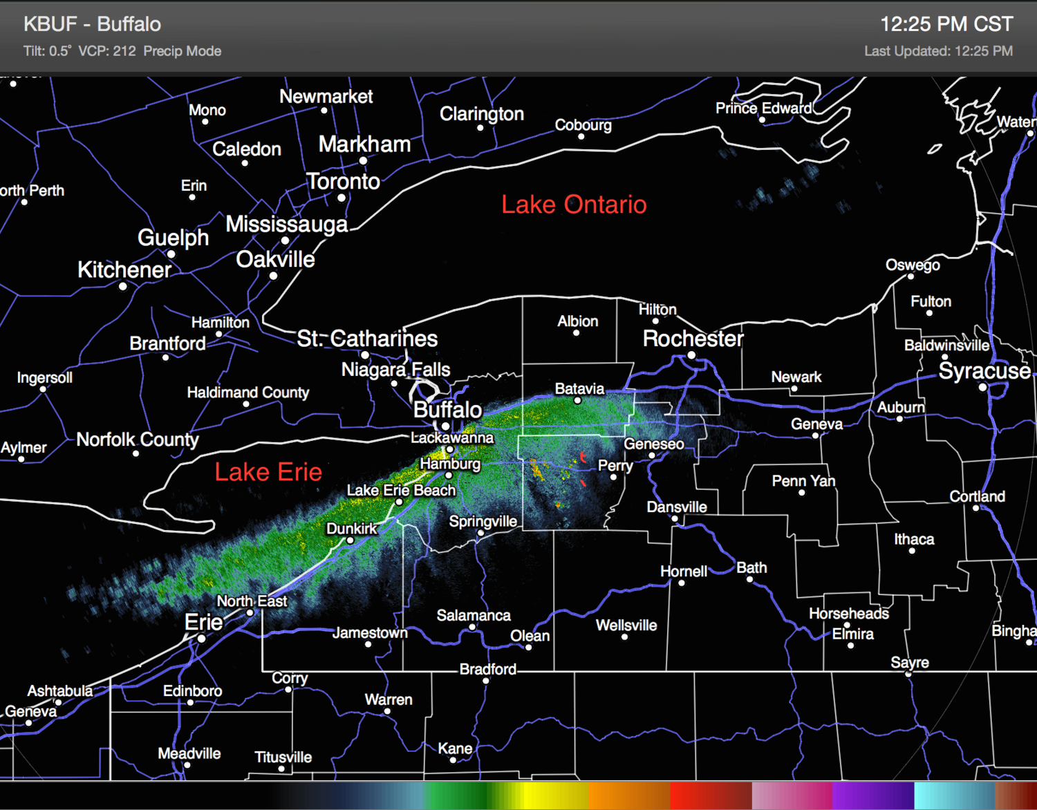
Unlike thunderstorms, which can strengthen and become destructive when wind direction and speed changes with height (wind shear), lake effect snow is most intense when wind shear is at a minimum. Uniform winds allow the snow to organize along a narrow band that moves very little, and these bands can grow to be over 150 miles long if the winds are aligned along the longest part of the lake. Midday radar images from the Buffalo area show a single band of lake effect snow that is over 120 miles long. A view of the lake from above shows the moisture billowing from the lake, and how well-defined and localized the band is.
Think that lake effect snow can't happen in Minnesota? Think again! Lake effect snow occurs along the north shore of Lake Superior frequently, early in the winter before the lake freezes over. Lake effect snow can also occur on some of Minnesota's larger inland lakes, like Lake Minnetonka and Lake Mille Lacs. While their shallow depths mean those lakes freeze over pretty early in the season, this early cold spell has generated lake effect flurries on both Minnetonka and Mille Lacs.