Minnesota Weather: Polar Vortex's Brief Reign Of Terror Coming To An End
MINNEAPOLIS (WCCO) -- It's dangerously cold again in Minnesota Wednesday night, but the mercury starts rising Thursday, according to Meteorologist Chris Shaffer.
So far in this bitter blast, the lowest wind chill we've seen is minus-66 in Ponsford, located a few miles west of Park Rapids. The coldest actual temperature was minus-48 near Roosevelt near Lake of the Woods.
The wind chill warning holds overnight, but is set to expire about 9 a.m. Thursday in the Twin Cities. Overnight lows will be similar to Tuesday, with wind chills in the minus-50s in northern Minnesota.
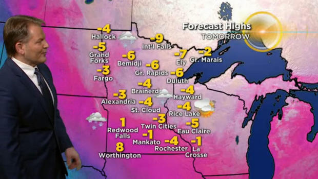
With a forecasted low of minus-27 early Thursday morning in the Twin Cities, it looks like another daily record will be set. Overnight lows in many towns, however, won't be as extreme as Tuesday.
Thursday's forecasted highs in Minnesota may be the most welcomed single-digit, sub-zero temps ever! Thursday will also be a lot less windy, so much of the brutal bite we've experienced the last couple days will subside.
There is also a good chance of snow Thursday in western and southern Minnesota, and it may just graze the Twin Cities, but it will likely be nothing more than a half-inch in most communities.
The bright, beautiful light at the end of the tunnel? Friday's high will be in the low 20s, Saturday's in the mid-30s, then we may hit the low 40s by Sunday. You may just fall back in love with Minnesota sooner than expected!