Minnesota Weather: Easter Snowstorm Could See Parts Of Minnesota Getting Double-Digit Snow Totals
MINNEAPOLIS (WCCO) -- If you're planning on wearing an Easter bonnet this weekend, you better make sure it's extra insulated. A winter storm system is expected to make its way into the state on Sunday, making one of the most beloved spring holidays look eerily familiar to our last few Aprils.
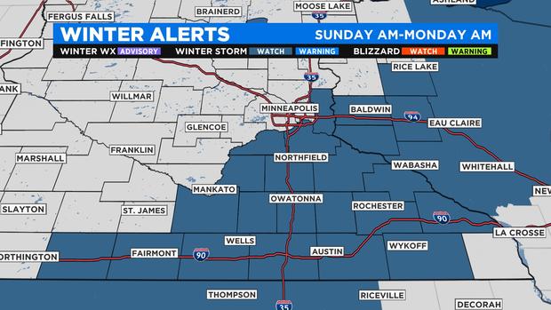
The National Weather Service has placed a number of counties just south and east of the Twin Cities under a winter storm watch, including Scott, Washington and Dakota counties.
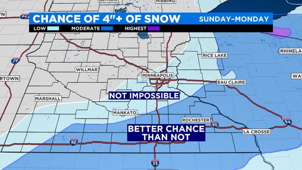
WCCO director of meteorology Mike Augustyniak says that plowable snowfall totals are most likely in the watch areas, but not impossible elsewhere. There is a much lower chance of measurable snow north and west of the Twin Cities metro area.
As for the timing of the storm, it's expected to make its biggest impact Sunday and Monday, but especially Sunday afternoon and evening. WCCO meteorologist Chris Shaffer said that this storm could drop snow at as fast a clip as an inch per hour at its peak.
Shaffer said that the Twin Cities themselves could see from 2 to 4 inches, with places like Hastings and Red Wing receiving considerably more. He added that there could be from 6 to 10 inches in a band stretching from the Rochester area on down toward Albert Lea.
Augustyniak says that there are some factors that are leading to a higher uncertainty than normal with this storm.
"A decrease in the amount of upper-air data fed into the models, because of a lack of commercial flights due to COVID-19, (and) the expected severe weather outbreak to our south, which could rob moisture" from the system in the upper Midwest, Augustyniak said.