Minnesota Weather: Quick Snowstorm Turns Easter Into Christmas; More Snow Monday
MINNEAPOLIS (WCCO) -- The Easter Bunny may have had the spotlight this Sunday, but it ended up looking a lot like Christmas.
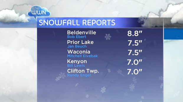
WCCO Meteorologist Lisa Meadows says the south metro saw the most accumulation, with 7.5 inches in Shakopee as of early Sunday evening, 7 inches in Apple Valley and 6 inches in Woodbury. Winds throughout the state were averaging in the 20-mile-per-hour range, but due to the temperature being near freezing point, the snow was heavy and wet, and wasn't able to blow around much. The snowfall did create poor visibility for drivers.
The storm system largely moved out of Minnesota by about 7 p.m. or so, with dropping temperatures following close behind. Much of the state will be in the low 20s overnight, with Monday's high returning to the mid-30s.
There is another chance for snow during Monday's evening commute, but it won't be anything like we saw Sunday, with accumulation in the metro expected to be at about 1 inch.
The below-average-temperature trend will continue through most of the week, with Tuesday being another cold one. But it looks like we'll gradually warm as the week progresses, with a possible shot at the low 60s by next weekend.