How Minnesota's Early Fall 'Micro-Season' Creates Picture-Perfect Weather
MINNEAPOLIS (WCCO) -- It's a time of year when there's often little to no heavy humidity, no blustery winds, and no rain to wash out our plans. Some might simply call it fall, but it's something more specific than the year's third season.
"Relocated from California thinking spring would be my favorite time of year and no, I absolutely love fall," said Chris Streiff Oji as she walked around White Bear Lake with her husband.
Her feeling is hard to argue as people grasp at the last few summer-like moments in the beginning of autumn.
"If we could have it like this all year it would be awesome," she said.
Unfortunately for her, those awesome conditions last just about two weeks, and they're happening right now. Dr. Kenneth Blumenfeld, senior climatologist with the Minnesota Department of Natural Resources (MDNR), described this time of year as a micro-season.

"This is a piece of what makes fall so spectacular," Blumenfeld said. "And that is to have clear skies, fair weather and generally nice, kind of agreeable conditions at the end of September and during early October."
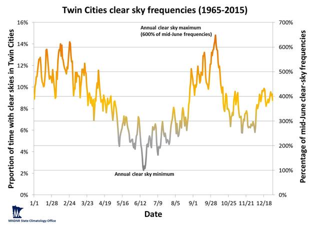
MDNR tracks which time of year on average has the highest probability of clear skies. The peak is the current pocket of early fall, six times more likely than the month of June. The sharpest spike in probability specifically happens between Sept. 27 and Oct. 3. Late January comes in second place, however clear skies that time of year often indicate a cold, below-zero temperature day.
"The atmospheric pressure tends to be a bit higher this time of year," he said. "That means that the air is kind of pushing down more on the earth and that prevents clouds from forming."
The micro-season is felt by people living across the Upper Midwest, stretching from Canada down to Missouri. University of Minnesota scientists discovered the weather pattern in the 1970s. And while cloudy, rainy, cool days can happen during this brief time period, the trend has continued over the decades. Dr. Blumenfeld said the clear sky probability is only around 15%, but that's higher than any other time of year.
"I think this is definitely something that people notice maybe subconsciously," he said.
While the percentage is low, it could be enough to convince people to schedule outdoor plans in the early fall in hopes of landing a perfect day.
"But you better have a plan B because if you don't get that spectacular weather, which is more common now than any other time of year, you might get something that you remember in a different way," he said.
Another unique weather trend during this same stretch is a wider range in the high and low temperature each day. The range typically peaks in the summer, before growing smaller as winter approaches. But in late September and early October, the clear skies allow for cooler nights and warmer days. According to MDNR, the average daily temperature range is 11.6 degrees from Sept. 20-28. It jumps 20.8 degrees from Sept. 29 to Oct. 4.
"We get into a pattern where we start losing moisture. All the vegetation starts drying out and that tends to kind of shut down the rainy season. And so the air dries out a little bit. That makes it easier to have the temperature change," Blumenfeld said.
What will it take to end this blissful stretch of weather? Typically, humidity returns as the temperature drops later in October. Clouds form more often, creating a gloomy chill that will have people reaching for sweatshirts and blankets as they head to a fall bonfire.