Minnesota Weather: Storm System Could Bring Plowable Snow Friday To Southern Minnesota
MINNEAPOLIS (WCCO) --A storm system churning over the Pacific Ocean is expected to hit Minnesota on Friday, likely bringing plowable snow to the southern part of the state, including the Twin Cities metro.
Meteorologist Mike Augustyniak says that while data is still coming in about the system, chances are it'll be a significant snowmaker, bringing some communities in southeastern Minnesota at least 8 inches of snow. The National Weather Service has issued a winter storm watch for the area.
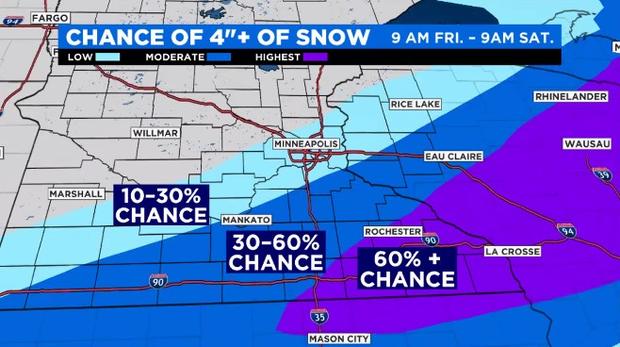
Current models predict the storm will move into southern Minnesota Friday morning, with the heaviest bands of snow likely across east-central and southeastern Minnesota, including the Minnesota River Valley, Mississippi River Valley, and the southern half of the Twin Cities metro. The snow is expected to fall through the evening and overnight hours, with snowfall rates up to an inch an hour possible in some areas.
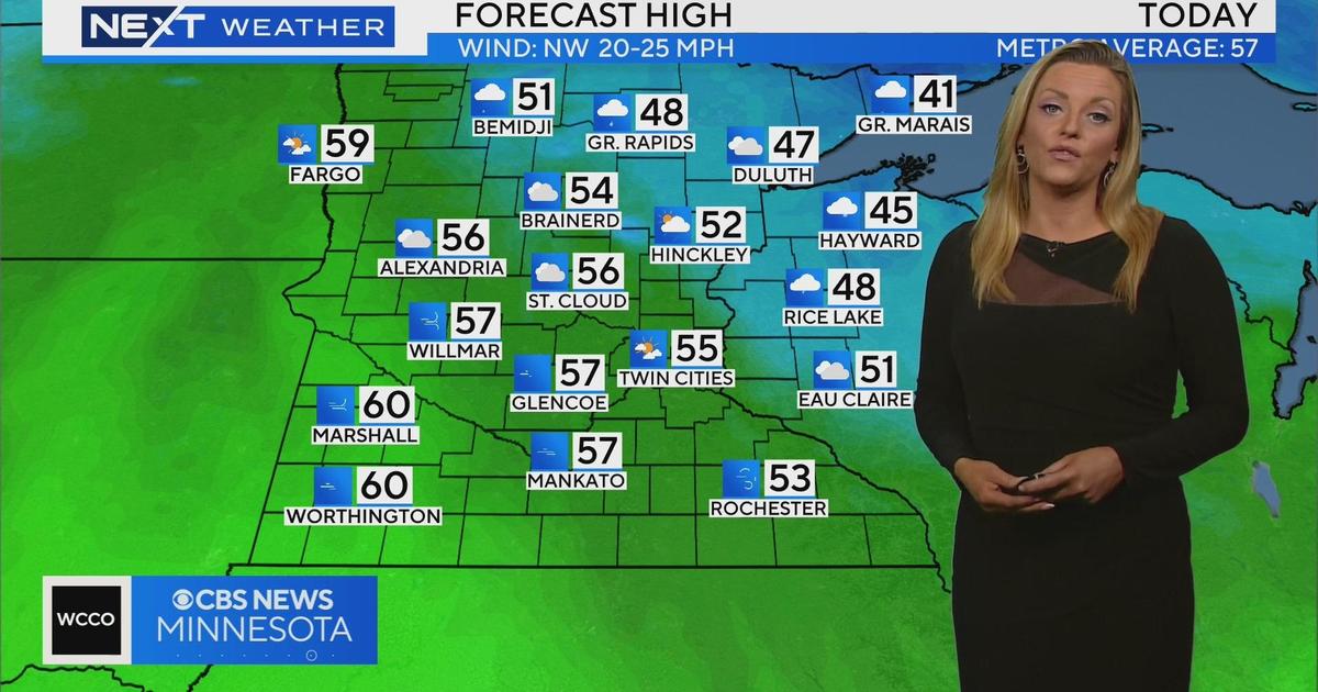
How much snow will the Twin Cities see? That's a difficult question to answer, as the heaviest snow bands looks to cut through the heart of the metro area. Augustyniak says that, right now, computer model guidance shows the metro receiving anywhere between 2 and 8 inches of snow, though the most-likely outcome is 2 to 5 inches of snow.
Cities along the Mississippi River Valley will likely see more snow from the system. Current models show the Owatonna area getting between 7 and 10 inches of snow.
Augustyniak cautions that, because this storm is still so far out to sea, the snowfall forecast will likely need to be refined in coming days.
Tricky Commute Thursday Morning
Before the snow hits Minnesota Friday, there's cause to be careful during the morning commute Thursday.
A small storm system looks to hit the Interstate 35 corridor in southern Minnesota during rush hour, bringing snow and perhaps sleet, depending on temperatures.
"The timing on this is not great," Augustyniak said. "Even a few tenths of an inch of snow during the morning commute, which is all I'm forecasting, can slick up the roads."
Temperatures will be mild Thursday, with highs reaching the mid-30s. That means the chemicals on the roads will be able to deal with any slick spots that develop ahead of Friday's snow.
A Chance At 60 Next Week?
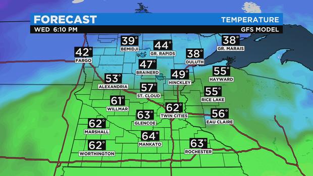
A significant warmup looks to be in store for next week.
According to Augustyniak, there's a nonzero chance that the Twin Cities sees temperatures in the 60s next Wednesday. For context, average high temperatures in Minneapolis for this time of year are in the upper 20s.
"I know it's going to be very warm," Augustyniak said, "but I don't know if 60s will get in here, because we'll probably still have snow on the ground."
Either way, the forecast over the next few days will give Minnesotans a reason to watch the weather.
"This is a crazy forecast," Augustyniak said.