Minnesota Weather: Schools Cancelling Classes Ahead Of Winter Storm Warning
WHAT WE KNOW
– The National Weather Service has issued a winter storm warning, which includes most of the Twin Cities
– A number of schools have already cancelled classes for Friday or plan to let out early
– The morning commute should be clear in the metro
– Snowfall in the Twin Cities is expected by late morning and will impact the evening commute
– Heavy, wet snow will fall across southern Minnesota through the overnight hours
– Accumulations close to a foot are possible in some areas
– Warmer temperatures and melting are in the forecast for next week
WHAT WE DON'T KNOW
– Where exactly the storm track (and heaviest snow bands) will fall
– Whether the Twin Cities will only see a couple inches of snow or closer to 6+ inches
WEATHER RESOURCES: School Closings | Radar | Weather App
MINNEAPOLIS (WCCO) -- A snowstorm tracking toward southern Minnesota threatens to dump a half-foot of snow on the Twin Cities on Friday, and already one metro school district has cancelled in-person classes.
The Rosemount-Apple Valley-Eagan School District said it's cancelling classes due to the coming snow and a shortage of bus drivers. Other south metro school districts, such as Bloomington Public Schools, Shakopee Public Schools, and Prior Lake/Savage Area Schools, say they'll be closing a few hours early, just as the heavy snow is expected to start falling.
Several other districts further south have canceled classes for the day. These include Northfield Public Schools, Mankato Area Public Schools, and Faribault Public Schools. A full list of school closings can be found here.
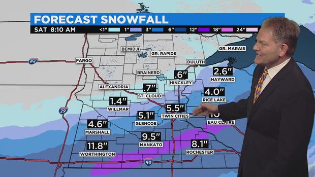
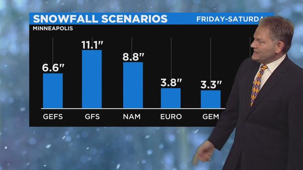
Meteorologist Chris Shaffer says that current models suggest the Twin Cities could see anywhere from a few inches to more than a half-foot of snow. The disagreement among models is due to the fact the heavy snow cut-off line looks to pass just north of the metro area. If that line shifts to the north or south, snow totals will be significantly affected.
Most of the metro area is currently under a winter storm warning, as is the rest of southern Minnesota. According to Shaffer, the heaviest snow bands could leave communities in southern Minnesota -- such as Worthington, Mankato and perhaps Red Wing -- with around a foot of snow.
During the heavy snowfall, travel will be hazardous. Weather officials says that if people must travel Friday evening, they should pack a flashlight, food and water in their vehicle in case of an emergency.
For much of central Minnesota, a winter weather advisory has been issued. About 2 to 4 inches of snow is expected in that area, which includes Willmar and the St. Cloud area.
Snowstorm Timeline
The storm system will push into southwestern Minnesota around 7 a.m., and it won't reach the Twin Cities until the late morning. That means the morning commute in the metro will be clear.
"If you want to run some errands and pick up some food, do it before noon," Shaffer said. "Because the snow will start to fly late morning tomorrow, and once it picks up in the afternoon, it's just not going to stop."
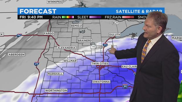
The heaviest snow bands look to fall along part of the Minnesota River Valley, extending just south of the Twin Cities. The snowfall will start with light snow before changing to wet, heavy flakes. The heavy snowfall is expected to continue into the overnight hours before the system pushes into Wisconsin early Saturday.
According to Shaffer, residents in the north metro should expect less snow than their south metro counterparts.
"If you're up in Blaine, for example, or Maple Grove, you will get much less snow than if you're in Lakeville, Burnsville or Farmington," he said.
City officials in Minneapolis say that there'll be around 50 plows out Friday clearing roads during the snowstorm.
Snow emergencies could be declared in the Twin Cities. Residents will want to be careful where they park Friday and Saturday.
After The Storm, Warmer Weather
Saturday looks to be clear, with sunny skies and temperatures in the low 30s. This should help as crews work to clear the roads of snow and ice. Additionally, a warming trend will kick-off Sunday, when temperatures are expected to climb above freezing.
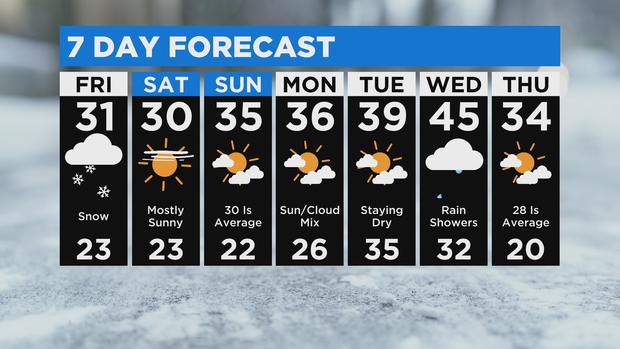
The warmer weather looks to extend through much of next week, peaking Wednesday when the mercury could reach the mid-40s in the Twin Cities. No matter how much snow Friday's storm brings, much of it will melt in the following days, and whatever's left could be washed away by a chance of mid-week rain.
For context, the average high temperature for mid-December in the Twin Cities is in the mid-20s. The average low is about 12 degrees.