Minnesota Weather: Historic December Storm Brings 2 Possible Tornadoes; Temps Will Drop On Windy Thursday
RESOURCES: Closures & Delays | Live Radar | Weather App
MINNEAPOLIS (WCCO) -- A rare winter thunderstorm possibly whipped up two December tornadoes in Minnesota Wednesday night -- an unprecedented event in recorded state history.
The National Weather Service said it will send one team to Freeborn and possibly Faribault County in Minnesota on Thursday to determine "whether damage was caused by a tornado or straight line winds" in the Hartland area. A crew will also be assessing possible tornado damage in Plainsview, Minnesota. In Wisconsin, crews will determine damage in Eau Claire County.
UPDATE: EF-0 Tornado Confirmed In Winona County, Making It MN's First-Ever Confirmed Tornado In December
If it's determined that was a tornado, it will be assigned a strength rating. Preliminary results are expected by late afternoon.
Our next challenge could be rain-soaked roads that ice over just in time for the Thursday morning commute. Anne Meyer with the Minnesota Department of Transportation says crews will have to wait before treating the roads.
"One big challenge with this particular storm is we can't pre-treat when it's raining. That material will wash away," Meyer said.
After the rain, MnDOT will move in before things freeze over by early Thursday morning.
"Here in the Twin Cities metro, crews are going to staff up around midnight," Meyer said. "We could also see some debris on roadways. That commute in the morning could be challenging."
As of late Wednesday night, Xcel Energy said more that 7,000 customers were without power, with 5,800 of those in southeastern part of the state.
Strong winds continued into Thursday, with gusts around 40 mph across the state. A Wind Warning will be in effect through 6 a.m. for much of Minnesota, and a Winter Storm Warning will be in effect for much of northern Minnesota.
About 1-3 inches will fall north of Interstate 94, and the Twin Cities may get a quick dusting, too. Snow showers should wrap up by the afternoon.
A possible tornado struck northwest of Albert Lea in Hartland just after 7 p.m., while another unconfirmed one hit just southwest of Wabasha. There are reports of heavy damage to a bank and several homes in Hartland, where winds topped 85 mph. There were no reported injuries.
WCCO spoke with a viewer named Lillie who was in Hartland as the storm passed through. She says her family went into the basement, bringing their dog and cat. She says it was very quiet, and then her mom described the roar of the wind as sounding like a train. When she felt like the danger passed, they walked about a block from their home to a main street and saw some of the damage. Lillie says they are without power Wednesday night.
The Twin Cities was under a Tornado Watch for several hours, which the National Weather Service canceled around 10 p.m.
WCCO Meteorologist Chris Shaffer says the rest of Minnesota dealt primarily with wind issues, with gusts in excess of 85 mph. Most reported damage just involved trees.
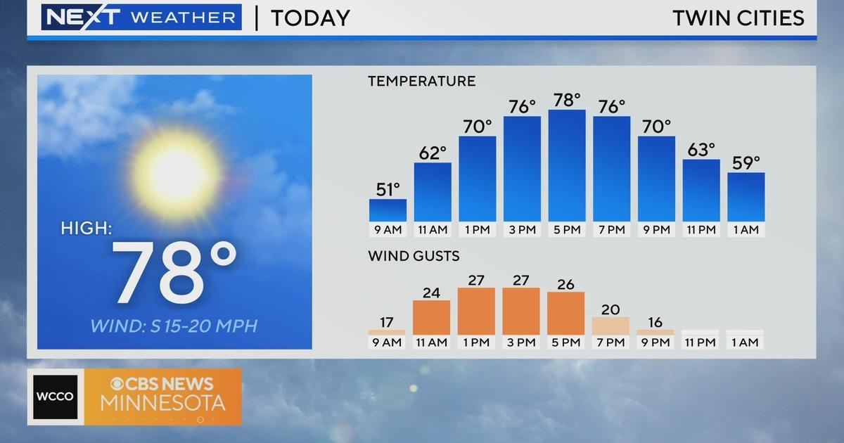
It got to 54 degrees in Twin Cities late Wednesday night, but it was below freezing in the Fargo/Moorhead area.
Temperatures will continue dropping through Thursday. The high in the Twin Cities will be a deceptive 30, since they already hit that in the morning hours and it will only get colder throughout the day.
More snow is possible on Friday and Saturday.
Below are previous weather updates:
UPDATE (8:40 p.m.): Xcel Energy is reporting that over 9,000 customers in Minnesota are without power.
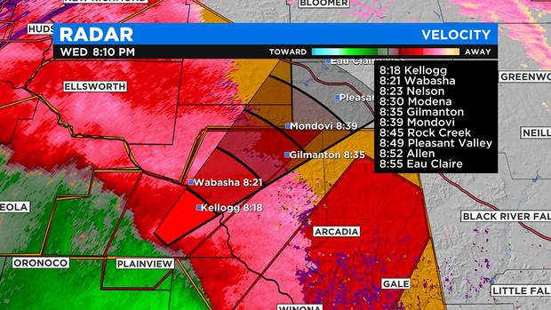
UPDATE (8:15 p.m.): Emergency management officials say a storm cutting across southeastern Minnesota has produced a tornado near Plainview.
Meteorologist Mike Augustyniak says the storm is moving northeast at 70 mph and is heading toward Kellogg and cities in western Wisconsin. Residents in the area are advised to seek shelter immediately.
UPDATE (8:02 p.m.): More tornado warnings have been issued for southeastern Minnesota and western Wisconsin.
The new warnings are in Wabasha and Winona counties and are set to last until 8:45 p.m. They include the cities of Plainview, Winona, and Wabasha.
A tornado warning is also in effect in western Wisconsin until 8:45 p.m.
Meanwhile, Xcel Energy is reporting that over 4,000 customers in Minnesota are without power.
UPDATE (7:50 p.m.): A severe thunderstorm warning has been issued for much of southeastern Minnesota, including the southern edge of the Twin Cities metro. Dakota, Goodhue, Rice, Winona, and Wabasha counties are all part of the latest warning, which is set to last until 8:30 p.m. Cities under the warning area include Northfield, Cannon Falls, Red Wing, Zumbrota and Pine Island.
Meanwhile, a second tornado warning has been issued for Olmsted County. A storm with radar-indicated rotation was spotted just east of Rochester, moving northeast toward Viola.
UPDATE (7:30 p.m.): A tornado warning has been issued for southeastern Minnesota.
The warning is in effect for parts of Fillmore and Houston counties until 8:15 p.m. Radar has indicated rotation, and cities in the path of the storm include Harmony, Preston, Lanesboro, and Rushford.
Those in the warning area are advised to seek shelter immediately.
UPDATE (7:34 p.m.): A severe thunderstorm warning has been issued for parts of Dodge, Fillmore, Olmsted, Wabasha and Winona counties in southeastern Minnesota. The warning area includes the cities of Rochester, Kasson, Chatfield, and Preston. The warning is set to be in effect until 8:15 p.m.
Forecasters say the storms could produce wind gusts up to 70 mph, penny-sized hail and possible tornadoes. Residents in the area are advised to seek shelter immediately.
The storm line is moving northeast along the I-35 corridor and looks to soon hit the Twin Cities metro area. An earlier tornado warning in south-central Minnesota has since expired.
UPDATE (7:18 p.m.): The severe thunderstorm warning has been extended to include parts of Rice and Steele counties, including the cities of Owatonna and Northfield. The warning is set to last until 8 p.m.
Radar shows the edge of the storm line moving northeast along the Interstate 35 corridor toward the Twin Cities metro area.
UPDATE (7:10 p.m.): A severe thunder warning has been issued for part of south-central Minnesota, including the cities of Mankato, Waseca and Le Center until 7:45 p.m.
Forecasters say there is the potential for damaging winds. Residents in the area are advised to seek shelter until the storm has completely passed through.
UPDATE (6:56 p.m.): A tornado warning has been issued for southeastern Freeborn County and western Faribault County until 7:30 p.m.
Forecasters say rotation was picked up on radar just east of Kiester. Residents in the warning area are advised to seek shelter immediately. Cities in the warning area include Alden, Conger, Manchester, Hartland and Geneva.
UPDATE (6:40 p.m.): A severe thunderstorm warning has been issued for Freeborn and Faribault counties along the Iowa border in south-central Minnesota until 7:30 p.m.
Those in the warning area are advised to seek shelter as damaging winds could fell tree branches and powerlines. According to radar images, the storm line is quickly moving northeast toward Albert Lea and Austin.
UPDATE (6:10 p.m.): Meteorologist Mike Augustyniak says that a weather balloon sent up Wednesday afternoon showed that stable air was above southern Minnesota at about 5,000 feet. So far, he says, this layer of air has prevented the stronger winds from the storm line from reaching the ground.
It's yet unclear if any new storm warnings will be issued. So far, the storm line has started to deteriorate the closer it gets to Minnesota.
Still, the National Weather Service says a line of storms is racing across southern Minnesota and will approach the Twin Cities metro around 7:30 p.m. Damaging winds will be a threat. Residents are advised to seek shelter if warnings are issued.
UPDATE (6 p.m.): The storms that prompted severe thunderstorm warnings in south-central Minnesota have weakened and moved out of the area. Still, the Twin Cities and southeastern Minnesota remain under a tornado watch until late Wednesday.
UPDATE (5:28 p.m.): The National Weather Service has issued a tornado watch covering the Twin Cities metro, southeastern Minnesota and western Wisconsin until 11 p.m.
"The main threat remains damaging wind gusts, but this powerful line of storms has spawned a few tornadoes," meteorologist Chris Shaffer said. "Hunker down at home, and stay away from windows."
Meanwhile, severe thunderstorm warnings have been issued for a number of counties in south-central Minnesota. Counties under the warning include Blue Earth, Faribault, Martin, Jackson, and Watonwan.
Forecasters say a line of storms is moving through the area, pushing northeast at a 80 mph. Those in the warning areas are advised to seek shelter, as this storm has a history of producing damaging wind gusts up to 90 mph.
The current warnings are set to last through 6 p.m. Locations in the storm line's path include St. James, Truman, Lewisville, Madelia, Crystal Lake.
UPDATE (5:05 p.m.): Meteorologist Mike Augustyniak says the National Weather Service is preparing to issue a tornado watch for southeastern Minnesota until 11 p.m. A squall line that's produced several tornado warnings across Iowa is tracking toward the area and expected to reach it around 8 p.m.
UPDATE (4:18 p.m.): A number of schools in southern Minnesota are delaying the start of classes Thursday. Among them are Lakeville Area Schools, which is delaying the start of classes by two hours.
To see a full list of closings, click here.
UPDATE (3:20 p.m.): Meteorologist Mike Augustyniak says the squall line that will move into southwestern Minnesota around 5 p.m. has produced widespread 70-90 mph wind gusts across Nebraska and Kansas. This line is moving northeast at 80 to 100 mph.
Meanwhile, the National Weather Service has issued a winter storm warning for much of central and north-central Minnesota.
This area is expected to see snow on the backend of the storm, and the combination of fresh snow plus strong winds could lead to greatly reduced visibility. Additionally, the expected drop in temperatures overnight could lead to moisture on the roads flash freezing, creating black ice.