Severe Thunderstorms Roll Through Twin Cities Metro, Bringing High Winds, Torrential Rains
MINNEAPOLIS (WCCO) -- A line of dangerous storms blew through Minnesota and Wisconsin Wednesday night, dropping possible tornados and heavy rain.
In the peak of the mid-evening, the metro area saw drivers dealing with street flooding in the Uptown neighborhood in Minneapolis. Pedestrians were caught in the storm struggling to hang on to their umbrellas downtown.
High winds dropped tree branches like one a viewer reported at a house in Richfield. There was also golf-ball sized hail pelting yards and homes in Apple Valley.
Xcel Energy reported more than 75,000 customers were without power.
"Hundreds of employees are out working to safely restore electric service to customers as quickly as possible. We understand that power outages can be a major inconvenience for customers, and we appreciate customers' understanding, patience and kindness as our crew members work to restore power," the company reported. "Please use caution when traveling in affected areas and stay away from downed lines. Contact Xcel Energy at 1-800-895-1999 to report downed lines or natural gas leaks."
-------
UPDATE (9:35 p.m.): The National Weather Service issued tornado warnings for Goodhue County in Minnesota, along with Pepin and Pierce Counties in Wisconsin until 10 p.m. Xcel Energy reports 75,000 customers without power in Minnesota, mostly in the Twin Cities.
UPDATE (9:05 p.m.): The National Weather Service has canceled the tornado warnings in the Twin Cities metro area as storms move through. More than 70,000 in the area still remain without power.
UPDATE (9 p.m.): More than 68,000 customers are now without power in the Twin Cities, according to Xcel Energy. The NWS issued a severe Thunderstorm Warning for Faribault County in MN until 9:15 p.m.
UPDATE (8:35 p.m.): More than 50,000 customers are without power in the Twin Cities, according to Xcel Energy, as severe storms roll through the core of the metro area Wednesday evening.
UPDATE (8:17 p.m.): A severe thunderstorm warning is in effect for Anoka, Chisago, Ramsey and Washington counties in Minnesota until 9:15 p.m.
UPDATE (8:11 p.m.): The tornado warning in Dakota County has been extended until 9 p.m.
UPDATE (8:09 p.m.): A severe thunderstorm warning is in effect for Blue Earth and Faribault counties in Minnesota until 8:45 p.m.
UPDATE (8:07 p.m.): A severe thunderstorm warning is in effect for Sherburne, Steele, Rice and Waseca counties in Minnesota until 8:45 p.m.
UPDATE (7:59 p.m.): A severe thunderstorm warning is in effect for Dakota, Rice and Scott counties in Minnesota until 8:45 p.m.
UPDATE (7:48 p.m.): A severe thunderstorm warning is in effect for Meeker, Stearns and Wright counties in Minnesota until 8:30 p.m.
UPDATE (7:42 p.m.): A tornado warning is in effect for Carver and Hennepin counties in Minnesota until 8:15 p.m.
UPDATE (7:39 p.m.): A tornado warning is in effect for Le Sueur and Rice counties in Minnesota until 8:15 p.m.
UPDATE (7:36 p.m.): A severe thunderstorm warning is in effect for Carver, McLeod and Wright counties in Minnesota until 8:30 p.m.
UPDATE (7:33 p.m.): A tornado warning is in effect for Carver and Scott counties in Minnesota until 8:15 p.m.
A severe thunderstorm warning is in effect for Blue Earth, Faribault and Martin counties until 8:15 p.m.
UPDATE (7:29 p.m.): A severe thunderstorm warning is in effect for Le Sueur, Rice and Scott counties in Minnesota until 8:30 p.m.
UPDATE (7:24 p.m.): Minnesota United FC's match tonight at Allianz Field in St. Paul is being delayed due to weather.
UPDATE (7:20 p.m.): A severe thunderstorm warning is in effect for Blue Earth, Le Sueur, Meeker, Nicollet, Stearns and Wright counties in Minnesota until 8 p.m.
UPDATE (7:14 p.m.): A severe thunderstorm warning is in effect for Carver, Scott and Sibley counties in Minnesota until 7:45 p.m. Blue Earth, Le Sueur and Nicollet counties in Minnesota are also under a warning until 8:15 p.m.
UPDATE (7 p.m.): A flash flood warning is in effect for Becker, Clay, Otter Tail and Wilkin counties in Minnesota until 1 a.m. Thursday.
UPDATE (6:59 p.m.): A tornado warning has been issued for McLeod, Renville, and Sibley counties in Minnesota until 7:45 p.m.
UPDATE (6:54 p.m.): A tornado warning has been issued for Martin and Watonwan counties in Minnesota until 7:30 p.m.
UPDATE (6:52 p.m.): A severe thunderstorm warning has been issued for Becker and Otter Tail counties in Minnesota until 7:15 p.m., and in Blue Earth, Brown and Nicollet counties in Minnesota until 7:45 p.m.
UPDATE (6:42 p.m.): A tornado warning has been issued for Nicollet and Sibley counties in Minnesota until 7:30 p.m.
The severe thunderstorm warning for Cottonwood and Jackson counties has been extended until 7:15 p.m.
UPDATE (6:41 p.m.): WCCO Meteorologist Mike Augustyniak provides some context on why the National Weather Service keeps re-issuing tornado warnings in southwestern Minnesota.
"They think there may be small tornado spin-ups embedded in the leading edge of that line of storms. These types of tornadoes — called QLCS, or Quasi-linear convective system tornadoes, can sometimes form and dissipate in just 30 seconds. Hence, the blanket warnings to keep people safe," Augustyniak said.
UPDATE (6:36 p.m.): A tornado warning has been issued for Renville County in Minnesota until 7:15 p.m.
UPDATE (6:33 p.m.): A severe thunderstorm warning has been issued for Nicollet, Renville and Sibley counties in Minnesota until 7:30 p.m.
UPDATE (6:31 p.m.): A tornado warning has been issued in Watonwan County, Minnesota, until 7:15 p.m. The warning in Brown County, Minnesota, has been extended to 7:15 p.m.
UPDATE (6:30 p.m.): A severe thunderstorm warning has been issued in Martin County, Minnesota, until 7:30 p.m.
UPDATE (6:25 p.m.): A severe thunderstorm warning has been issued in Kandiyohi and Meeker counties in Minnesota until 7 p.m.
UPDATE (6:22 p.m.): The tornado warning in Cottonwood and Jackson counties has been extended until 6:45 p.m.
A severe thunderstorm warning has been issued in Brown, Renville and Watonwan counties in Minnesota until 7 p.m.
UPDATE (6:13 p.m.): A tornado warning has been issued for Brown and Redwood counties in Minnesota until 6:45 p.m.
UPDATE (6:10 p.m.): A severe thunderstorm warning is in effect in Cottonwood and Jackson counties in Minnesota until 6:45 p.m.
UPDATE (5:58 p.m.): The tornado warning in Cottonwood County, Minnesota, has been extended until 6:15 p.m.
A severe thunderstorm warning has been issued for Redwood, Renville and Yellow Medicine counties in Minnesota until 6:30 p.m. Brown and Redwood counties in Minnesota are also under the warning until 7 p.m.
UPDATE (5:53 p.m.): A tornado warning has been issued for Jackson County, Minnesota, until 6:15 p.m.
UPDATE (5:37 p.m.): A tornado warning has been issued for Cottonwood County, Minnesota, until 6 p.m.
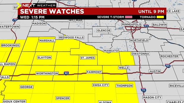
UPDATE (5:30 p.m.): Much of central and southern Minnesota are under a tornado watch until midnight Thursday -- including the Twin Cities. Several counties in western Wisconsin are also included in the watch.
Minnesota: Anoka, Benton, Blue Earth, Brown, Carver, Chippewa, Chisago, Dakota, Dodge, Faribault, Fillmore, Freeborn, Goodhue, Hennepin, Isanti, Kandiyohi, Le Sueur, McLeod, Martin, Meeker, Mower, Nicollet, Olmsted, Pope, Ramsey, Redwood, Renville, Rice, Scott, Sherburne, Sibley, Stearns, Steele, Swift, Wabasha, Waseca, Washington, Watonwan, Winona and Wright.
Wisconsin: Barron, Buffalo, Dunn, Pepin, Pierce, Polk, St. Croix.
UPDATE (4:29 p.m.): A severe thunderstorm warning has been issued for Pine County, Minnesota, and in Burnett County, Wisconsin, until 5:15 p.m.
UPDATE (4:09 p.m.): A severe thunderstorm warning has been issued for Lincoln and Pipestone counties until 4:30 p.m.
UPDATE (3:59 p.m.): A severe thunderstorm warning has been issued for Pine County until 4:30 p.m.; and in Chisago, Isanti, Kanabec, Mille Lacs and Sherburne counties until 5 p.m.
UPDATE (3:21 p.m.): A severe thunderstorm warning has been issued for Isanti, Mille Lacs and Sherburne counties until 4 p.m.
UPDATE (3:04 p.m.): A severe thunderstorm warning has been issued for parts of Meeker, Stearns and Wright counties until 3:45 p.m.
According to forecasters, the storm cell is moving northeast in the direction of Lichfield, Annandale and Clearwater.
The storms threaten to produce wind gusts up to 60 mph and quarter-sized hail.
UPDATE (2 p.m.): The tornado warning for parts of Martin and Watonwan counties has expired. Still, much of southwestern Minnesota is under a tornado watch until 9 p.m.
Severe storms are expected to move over southwestern Minnesota in the coming hours, and they threaten to produce tornadoes, large hail, and damaging wind gusts up to 75 mph.
As the storms move northeast through the afternoon, they'll arrive in the Twin Cities metro are around the time of the evening commute. While the storm are expected to weaken into the night, they could still bring hail, damaging winds and heavy rain.
UPDATE (1:51 p.m.): WCCO Director of Meteorology Mike Augustyniak says that while the tornado warning continues for parts of Martin and Watonwan counties, the radar presentation was not remarkable with this cell.
Still, the warning was issued as the National Weather Service Twin Cities received a photo from a storm chaser showing the cell producing a wall cloud.
The warning is still set to expire at 2 p.m.
UPDATE (1:33 p.m.): A tornado warning is in effect for parts of Martin and Watonwan counties until 2 p.m.
Forecasters say radar indicated rotation and a possible tornado. The swirling storm cell is moving northeast, toward the cities of Trimont, Ormsby and Truman.
The storm is also capable of producing quarter-sized hail, weather officials say. Residents in the area are advised to seek shelter indoors.
UPDATE (1:15 p.m.): The National Weather Service has issued a tornado watch Wednesday for several counties in southwestern Minnesota.
According to forecasters, the watch is set to last until 9 p.m. It includes Blue Earth, Brown, Cottonwood, Faribault, Jackson, Lincoln, Lyon, Martin, Murray, Nobles, Pipestone, Redwood, Rock, Waseca, and Watonwan counties.
Storms expected to move over the area in the coming hours could produce tornadoes, large hail, and damaging wind gusts up to 75 mph.
Small cells also triggered severe thunderstorm warnings in parts of south-central Minnesota over the last hour.
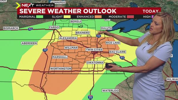
MINNEAPOLIS (WCCO) -- Prepare for back-to-back Next Weather Alert days, as severe storms that could produce tornadoes are possible Wednesday and Thursday. There's also extreme heat in the forecast.
Two batches of thunderstorms are making their way through the state; one system covering Brainerd through the west metro is moving to the northwest. A severe thunderstorm warning for Carver, McLeod, and Wright Counties says there's potential for quarter-sized hail to drop until 1 p.m. The Marshall area is also under a severe thunderstorm warning with threat for golf ball-sized hail.
Thunderstorms could roll through the metro around 8 p.m., bringing damaging winds.

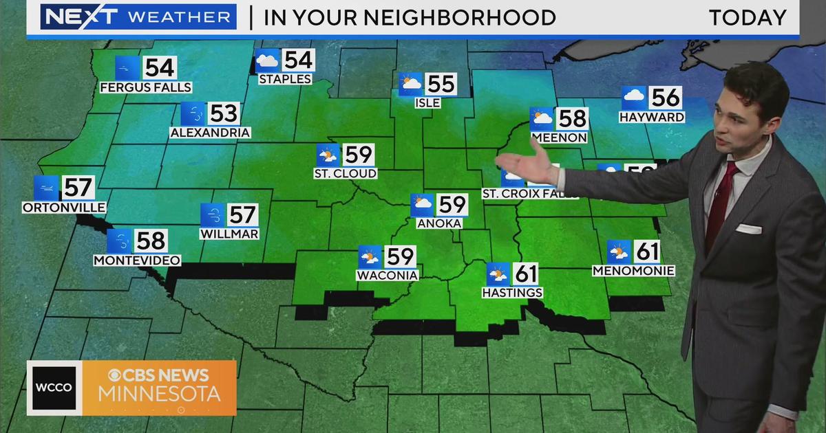
A warm front is going to lift throughout the day, which will bring in heat and humidity. Temperatures and the dew point will rise as the day rolls on, with the high in the Twin Cities forecasted at 83 degrees. It'll be a few degrees warmer to the south, and central and northern Minnesota will top out in the 70s.
Next Weather Alert: Hail, Damaging Winds & Possible Tornadoes
The WCCO weather team said storms will develop in southwestern Minnesota between 3 and 4 p.m., then move northeast across the state. The southwest is under an enhanced risk for severe weather, and that's where the tornado threat is greatest.
As the storm system moves northeast, the threat will turn to heavy rain and large hail. The system should arrive in the Twin Cities around 5 p.m., then move into northern Wisconsin later in the night.
Flooding is also possible overnight.
We'll take a little breather Thursday morning, then another round of severe weather is possible starting in the afternoon. The greatest storm threat will be from west-central to northern Minnesota.
Thursday will be flat-out hot and humid, with a high of 90 in the metro. It will also be a very windy day. It will all settle down Friday, and it should be a calm and humidity-free fishing opener weekend, with temps in the 70s.