WCCO-TV Road Tests Four Free Traffic Apps
MINNEAPOLIS (WCCO) -- It has been a long, frustrating winter of nightmare commutes for many drivers. Whether it's snow, a crash or construction back-ups, some apps on the market promise to steer you around all the gridlock.
We follow their commands and often don't question the roads they lead us down. Anything to make the drive to our final destination less stressful.
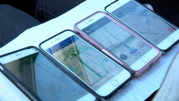
But we wondered which traffic app does the best job. With the help of Pioneer Press tech writer Julio Ojeda-Zapata, we focused on four free apps: Google Maps, Apple Maps, Inrix, and Waze.
We navigated to the same destination: Our WCCO-TV studios in downtown Minneapolis from about five miles away in Richfield, winding north around the noon hour on the years-long construction project on Interstate 35W.
Take a look at how long each app says it will take to get there: Eight minutes on Google, nine on Apple and Waze. Inrix registers a 13-minute drive. That's five minutes and nearly three miles longer. You'll see how those times turn out once we hit the road.
"If the route doesn't seem right to you, if you're not happy with it, fire up another app and see what it says," Ojeda-Zapata said.
He gives Google Maps the top spot in his research.
"It will fit the needs of most people in most situations," he said.
Free of clutter, he likes the look of the app when you run into congestion. He also calls it the best for bicycle commuters.
"It does public transit and bicycle routing, which is great," Ojeda-Zapata said.
He believes Apple Maps is best for those with that fancy watch.
"If you're an iPhone user and you have an iPhone and you have an Apple Watch, the iPhone and the Apple Watch work together," Ojeda-Zapata said.
Different vibrations signal to turn left or right.
"Waze is the traffic app on steroids," he said. "It does a lot."
A social network of sorts, Waze users are constantly reporting info from construction zones to road hazards like potholes. It even shows your speed on the road.
"If you're really obsessed with what's going on with traffic, Waze is fantastic," Ojeda-Zapta said.
Inrix is the same technology you will find in the dashboard of luxury cars. In our repeated tests, it seemed to overestimate how long it would take to get there.
"Looks like Google and Apple were spot on from the beginning," Collin said.
Those two timed out right.
Ojeda-Zapata told WCCO-TV he recognizes most iPhone users won't download anything else on their phones, but he thinks Google Maps is especially worth the download and users will notice a difference.
Google Maps (iPhone and Android)
- Best overall choice for most users (Apple and Google)
- Good traffic-conditions color coding
- Shows crashes, construction and closed routes
- Shows recommended and alternate routes
- Tells you when to leave, based on traffic conditions, so you get there on time
- Google Assistant integration for verbal requests
- Lyft and Uber integration
- Also has excellent public-transit and bicycling-path routing
Apple Maps (iPhone) - Default choice for Apple users (already installed on iPhone and iPad)
- Shows fastest route based on traffic conditions
- Traffic-conditions color coding is hard to read
- Shows crashes, road work, closed routes and general alerts
- A must-use if you have an Apple Watch (which vibrates to guide you)
- Also has public-transit routing
- Uber integration
Waze (iPhone and Android)
- Crowd-sourced traffic conditions. Get alerted about police, accidents, road hazards and traffic jams, all shared by other drivers in real time
- "OK Waze" voice integration to report a traffic jam, road hazard, accident or speed trap without taking your hands off the wheel
- Connect calendar and Facebook events to make sure you get to events on time
- Advance drive planning to make sure you get there on time
- Will also help you find a parking spot
- Maps, gas-pump prices also crowd-sourced
- Sleep mode to save battery capacity
INRIX Traffic (iPhone and Android)
- Crowd-sourced traffic conditions (similar to Waze) and mapping (via OpenStreetMap)
- Alerts about traffic slowdowns, police activity, accidents, events, construction, road closures and hazards on your route
- Weather factored in. Get alerts about hazardous driving conditions due to snowstorms, etc.
- Save your favorite places for real-time ETAs and alternate routes based on traffic. App also learns your habits and provides advice accordingly
- Traffic forecasting. Pick your future drive time to see what conditions will be like
- Will also help you find a parking spot
- Same tech found in dashboards of BMW, Porsche, Audi, Tesla and Ford cars