Minnesota Weather: Winter Storm Tracking Right For The Twin Cities, Could Dump 9 Inches Of Snow
MINNEAPOLIS (WCCO) – A powerful winter storm is expected to descend Friday on Minnesota, with the heaviest snow looking to fall over the Twin Cities, leaving metro residents digging out from up to 9 inches of fresh snow.
The National Weather Service has issued a winter storm warning for much of central and southern Minnesota, including the metro area, as well as western Wisconsin. The warning is slated to last until Saturday afternoon.
RELATED: Download The WCCO Weather App
⚠️NEW:
Winter Storm Warnings have been issued for areas that stand the best chance of seeing 6-8" or more of snow. Watch the official @Wcco forecast 24/7 at https://t.co/qjHiEsP0O0 pic.twitter.com/AdwAzb71NS— Mike Augustyniak (@MikeAugustyniak) January 16, 2020
Forecasters say the storm will arrive late Friday morning. The heaviest snow looks to fall during the afternoon and evening hours. Commuters should expect a slow and messy drive home. If possible, drivers may want to consider leaving work early.
For air travelers, delays and cancellations are expected at Minneapolis-St. Paul International Airport. Delta Air Lines is one carrier already offering travel waivers.
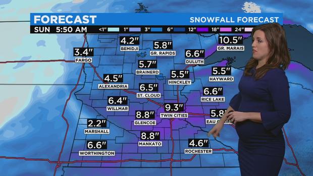
As for snow totals, 7 to 10 inches could fall in communities around the Twin Cities, depending on where the heaviest bands of snow line up. Slightly lower amounts are expected for the greater part of southern and central Minnesota.
Northern Minnesota is expected to see between 3 to 6 inches of snow, with higher totals along the North Shore, where up to 10 inches of snow could stack up.
Meteorologists say the snow looks to gradually taper off after midnight Friday, with the storm moving out of the state by Saturday afternoon. However, strong winds Saturday could lead to blowing snow and drifting, making travel hazardous in open areas.
Following the storm, temperatures will plunge, making for a frigid weekend. Subzero lows are expected for Sunday and Monday. The cold won't last too long, however, as temperatures look to rebound to average by mid-week.
For those of you that like to visualize the forecast...
On Friday heavy snow will lift northward across the region. Then a break Friday night. Then STRONG northwest wind gusts of 35 to 45 mph causing blowing and drifting snow #mnwx #wiwx pic.twitter.com/x6uN9i7s6p— NWS Twin Cities (@NWSTwinCities) January 16, 2020