Minnesota Weather: Wind Chill Advisory Extended Through Monday, Warm-Up Begins Tuesday
MINNEAPOLIS (WCCO) -- After a frigid weekend, Monday won't bring any relief from the arctic cold.
The National Weather Service has extended a wind chill advisory for the Twin Cities metro until 9 a.m. Tuesday. Wind chill factors could be as low as 35 below zero, cold enough for frostbite to set in on exposed skin in just minutes.
Outside of the Twin Cities, which is relatively warmer than the rest of the state, a wind chill warning is in effect until 10 a.m. Monday. Wind chill factors could be as frigid as minus-40 degrees.
Overnight, air temperatures were as low as minus-25 degrees in the Twin Cities. In parts of northern Minnesota, the mercury dipped to minus-35 degrees.
On Saturday, records were set for the lowest high temperature in Duluth, the Twin Cities, St. Cloud, and Rochester. A record was missed by just two degrees Sunday, with the high hitting minus-4 degrees in the Twin Cities. Keep in mind, the average temperature for Valentine's Day is 29 degrees.
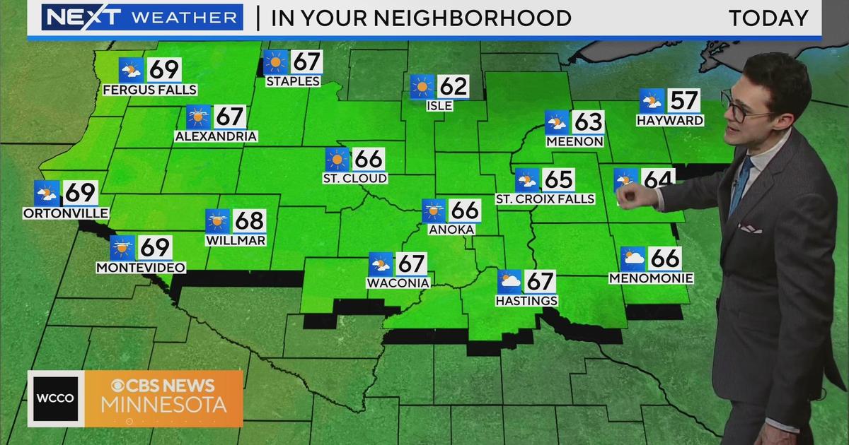
There will be plenty of sunshine Monday, but temperatures will stay just below zero in the metro. Most of the state will see highs that are a few degrees colder.
If you can get past Monday night, a warm-up is your just reward. Forecasters say Minnesota will finally get above zero Tuesday, with a forecasted high of 6 degrees. A stretch of highs in the teens follows, and we'll be back in the 20s and 30s by next weekend.