Minnesota Weather: Storm Bands Expected To Weaken During Overnight Hours
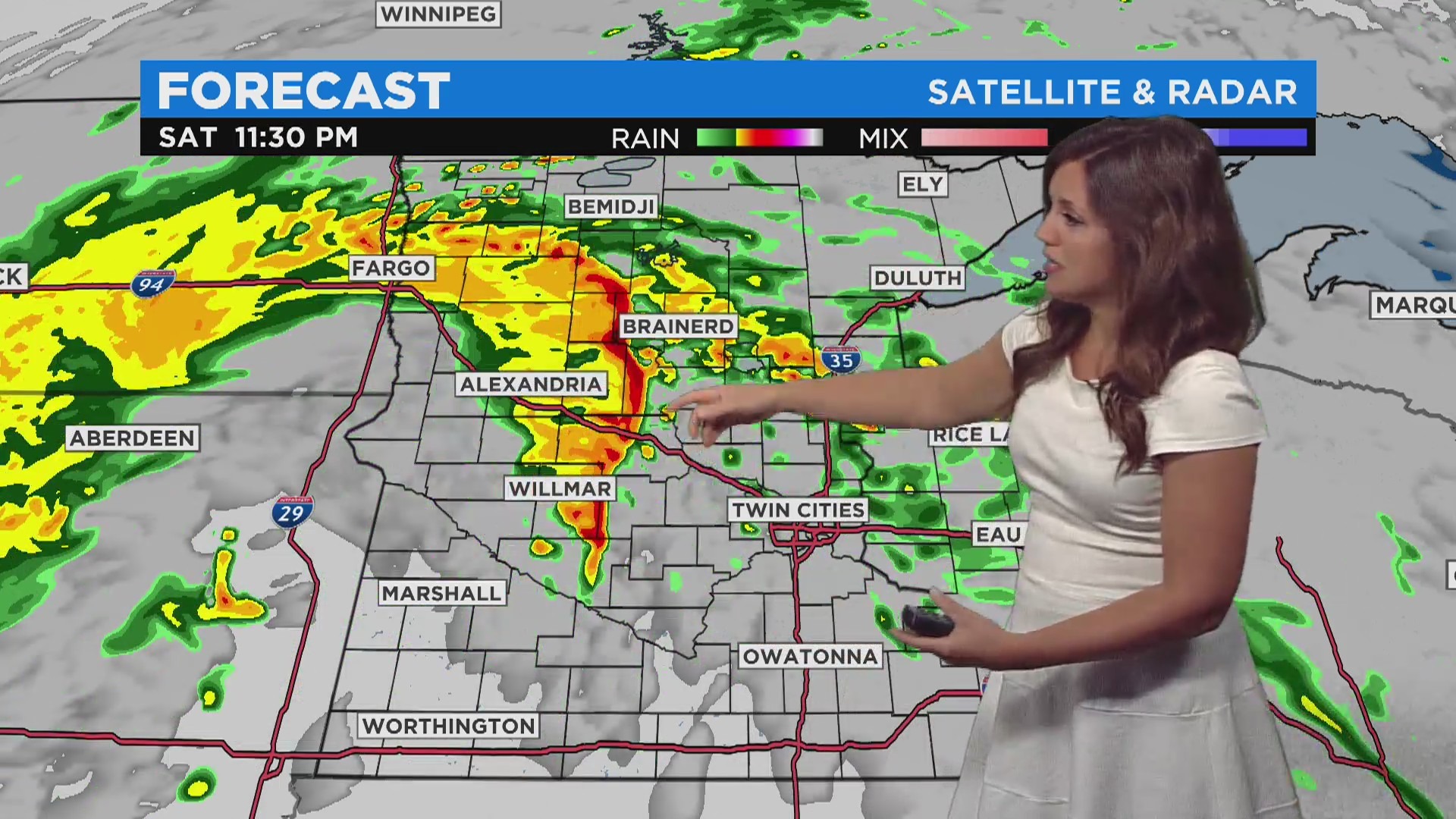
UPDATE (11:25 p.m.): Showers and storms are expected to wash over central and northern Minnesota over the next several hours. A severe thunderstorm watch is in place for a number of central Minnesota counties until 2 a.m.
Meteorologist Chris Shaffer says the storm bands will weaken and break apart as they extend into northeastern Minnesota in the early hours of Sunday morning.
After that, skies will clear, but the low pressure system swirling over the Midwest will likely bring another round of showers and storms Sunday for parts of western and northern Minnesota.
The rain that fell Saturday was much-needed for parts of northwestern Minnesota, as the area was heavily impacted by the summer's historic drought. Temperatures Sunday are expected to remain above average, with highs in the low 70s.
UDPATE (9:37 p.m.): : A flood warning is in effect for southeastern Big Stone County in west-central Minnesota until 6:30 a.m. Sunday.
Weather officials say that rainfall amounts up to 1 inch are possible, which could lead to localized flooding. Motorists are advised not to drive on flooded roads, as most flood deaths occur in vehicles.
UPDATE (8:22 p.m.): The line of severe storms is moving deeper into central Minnesota. Severe thunderstorm warnings are now in effect for Douglas and Pope counties until 9 p.m.
The National Weather Service says the storms are moving toward Alexandria at about 55 mph. Threats include 60 mph wind gusts and nickel-sized hail.
UPDATE (8 p.m.): Severe thunderstorm warnings are in effect for Lac qui Parle, Stevens and Swift counties until 8:45 p.m.
Forecasters say the storm system is moving northeast at 50 mph, threatening 60 mph wind gusts and quarter-sized hail.
UPDATE (7:29 p.m.): Severe thunderstorm warnings are now in effect for Grant, Otter Tail and Wilkin counties until 8:30 p.m.
The National Weather Service says the storm line is moving about 50 mph across west-central Minnesota, threatening 60 mph wind gusts and quarter-sized hail.
UPDATE (7:21 p.m.): Severe thunderstorm warnings are in effect for parts of Big Stone, Lac qui Parle, Traverse, Stevens and Swift counties until 8 p.m.
UPDATE (6:59): Tornado warnings are in effect for parts of Big Stone and Traverse counties until 7:30 p.m.
UPDATE (6:43 p.m.): Much of west-central and central Minnesota are now under a severe thunderstorm watch until 2 a.m. Sunday.
The affected counties are: Becker, Cass, Chippewa, Crow Wing, Douglas, Grant, Hubbard, Kandiyohi, Lac qui Parle, Meeker, Morrison, Otter Tail, Pope, Renville, Stearns, Stevens, Swift, Todd and Wadena counties.
Meteorologist Chris Shaffer says the chief concerns from these storms will be damaging winds and hail. Isolated tornadoes are also possible.
Forecasters predict the storm line will weaken as it moves deeper into central Minnesota through the evening hours. The system is expected to stay in northern Minnesota, bringing rain and possible storms to the area on Sunday.
UPDATE (6:18 p.m.): A severe thunderstorm warning has been issued for parts of Big Stone and Traverse counties until 7:15 p.m.
The National Weather Service says the lines of storms threaten hail, wind gusts up to 60 mph and possible tornadoes.
UPDATE (3:20 p.m.): A severe thunderstorm watch has been issued for counties in extreme west-central Minnesota.
According to the National Weather Service, the counties under the watch are Big Stone, Traverse, and Wilkin counties. The watch is slated to last until 10 p.m.
MINNEAPOLIS (WCCO) - Saturday will start out with sunshine and warm temperatures, but there will be a chance for severe weather in the western part of the state in the evening.
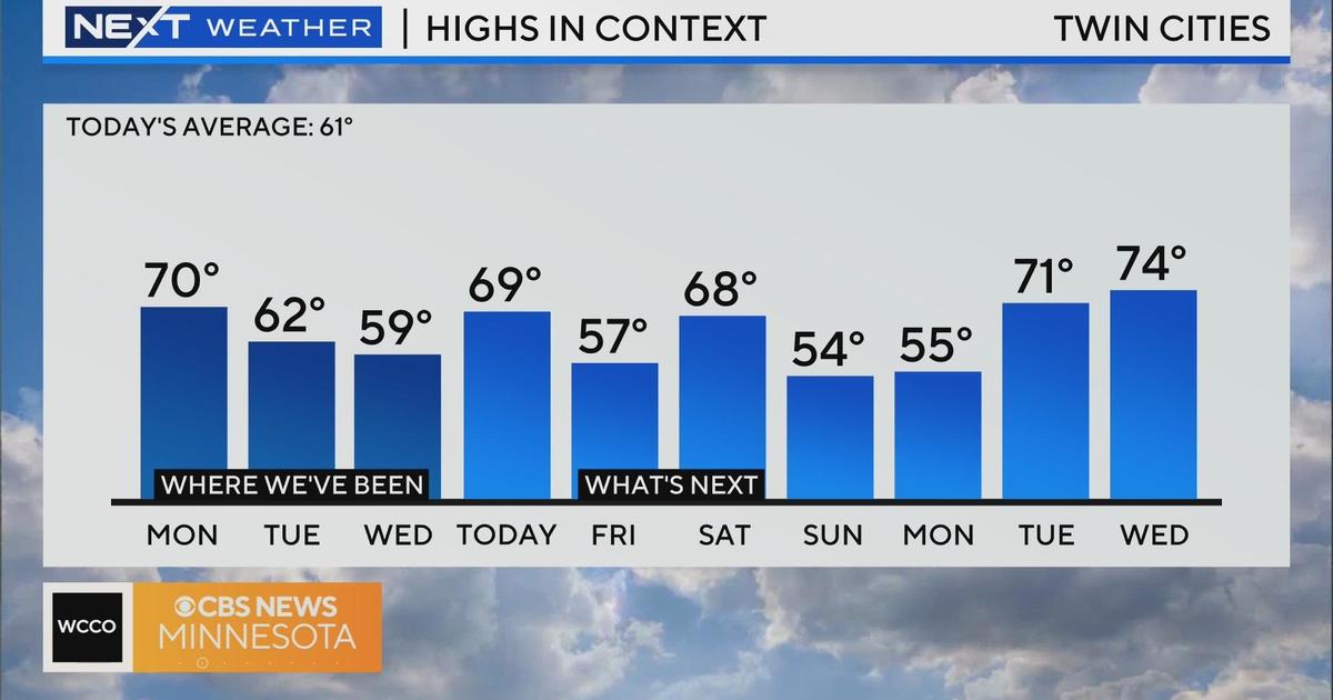
High temperatures are forecasted for 78 degrees in the Twin Cities area. The morning will see lots of sun - especially in central and southern Minnesota - but clouds will develop in the afternoon.
In western Minnesota, after an initial bout of rain in the afternoon, there will be a slight chance for severe weather starting around 8 p.m. WCCO meteorologist Katie Steiner says there is a possibility for strong winds and large hail until midnight in areas such as Alexandria and Brainerd.
Temperatures will be around 63 degrees overnight, which is very warm for this time of year. Then, a high of 70 degrees is possible in the Twin Cities on Sunday.
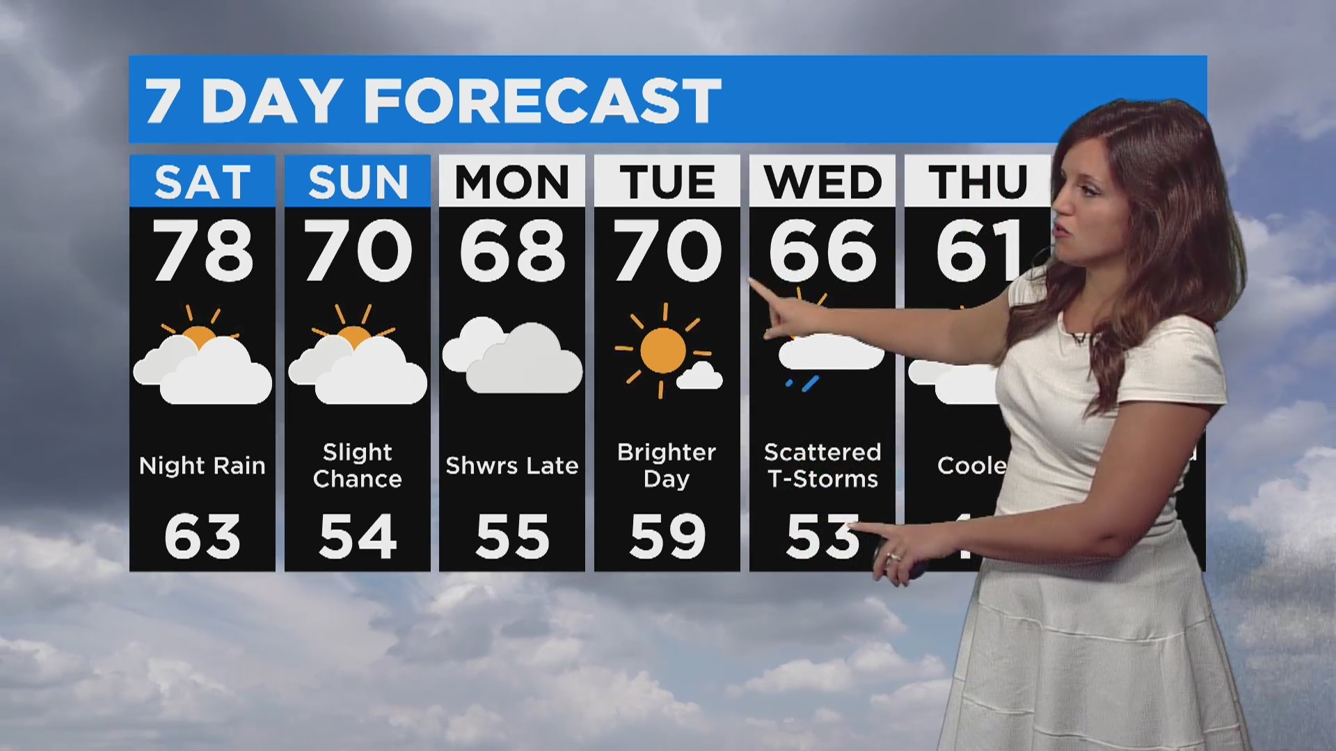
There is a chance for spotty showers on Sunday, especially in central Minnesota. After that, the rain should clear out until mid-week. Wednesday could see some scattered thunderstorms, and by Thursday, temperatures should be cooler and closer to average.