MN Weather: Severe Storms Roll Across Southern Part Of State
MINNEAPOLIS (WCCO) -- Two rounds of severe weather moved across Minnesota Tuesday. Here are the latest updates:
UPDATE (11:35 p.m.): A tornado warning is in effect until 12 a.m. Wednesday in Fillmore, Olmsted and Winona counties.
UPDATE (11:10 p.m.): A tornado warning has been extended in Fillmore and Mower counties until 11:30 p.m.
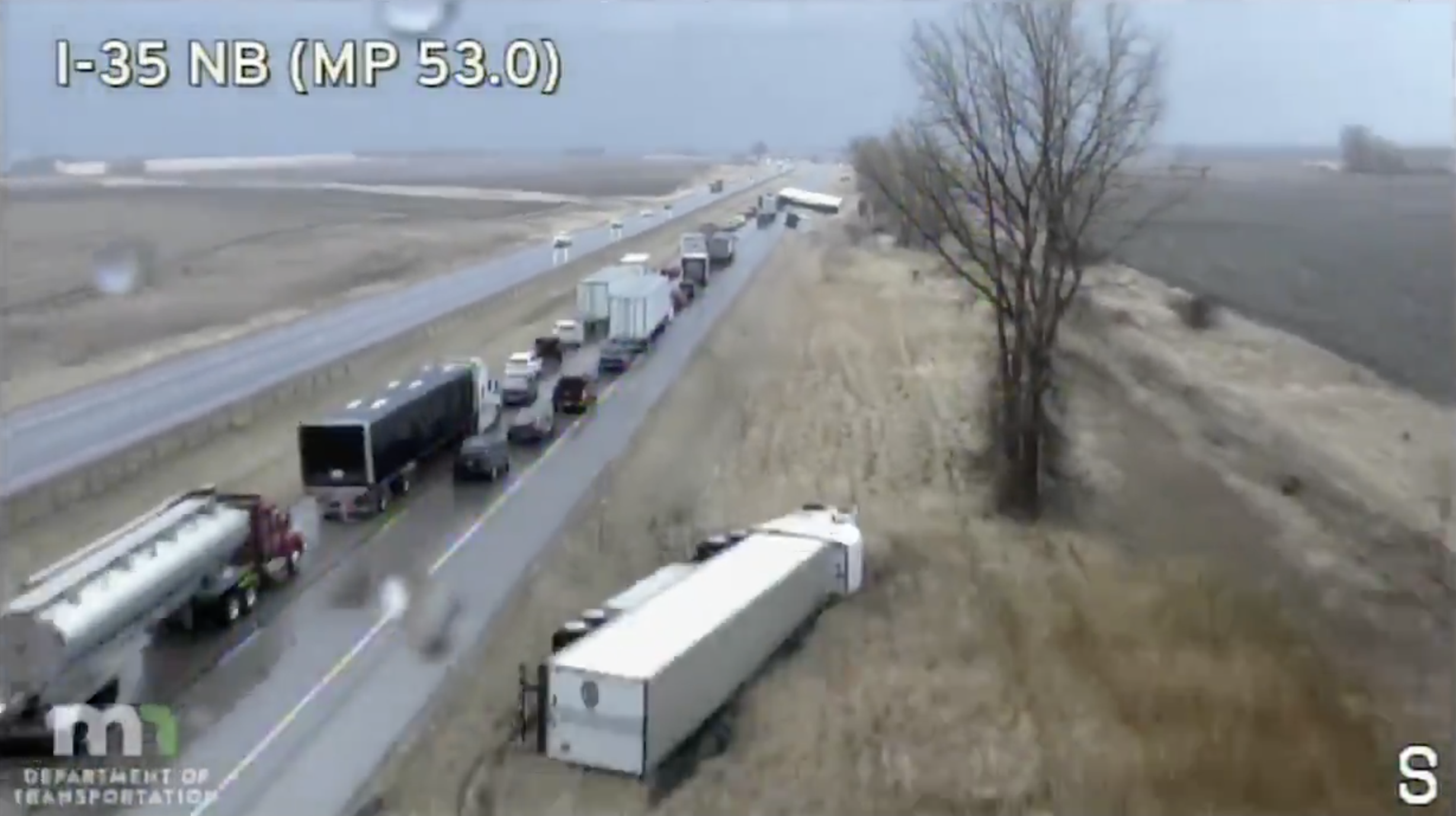
UPDATE (11 p.m.): WCCO Chief Meteorologist Chris Shaffer says a massive tornado moved across Iowa Tuesday afternoon, but nothing that severe has occurred yet in Minnesota. The most extensive damage seemed to be centered in Faribault, where nine semis were blown over by a downburst from an intense thunderstorm that passed over Interstate 35 in the afternoon. Trees were also uprooted in town, some powerlines were knocked down, and plenty of rooftops lost shingles.
It will be a long night for folks in southeastern Minnesota, with heavy rain, lightning and thunder. Shaffer says sump pumps will be "burping all night long" due to the impressive rain totals.
The Twin Cities metro area is still under a severe thunderstorm watch until midnight, but those may expire earlier.
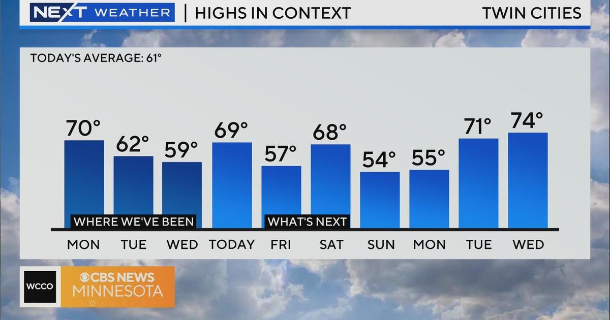
We'll catch a break Wednesday, with some scattered showers expected early in the day. There may also be a bit of sunshine later in the day, but it will be windy and not as warm. The day will start out mild, with a high of 50 forecasted in the metro -- but temps will drop like a rock by the evening, with a low of 30 expected.
Thursday may feature a wintry mix, and temps will remain in the low 40s and upper 30s through early next week. Things will dry out Saturday and Sunday, but there are a few flakes possible on Easter Sunday.
UPDATE (10:45 p.m.): A tornado warning has been issued in Fillmore and Mower counties until 11 p.m. Those counties are also under a severe thunderstorm warning until 11:30 p.m.
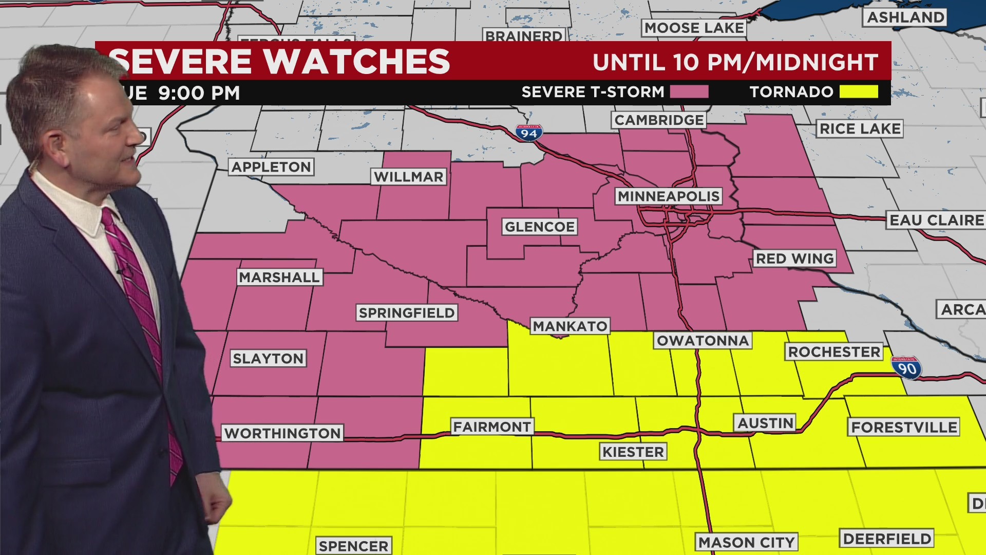
UPDATE (10 p.m.): A tornado watch is in effect for Blue Earth, Faribault, Freeborn, Martin, Steele, Waseca and Watonwan counties until midnight. Faribault, Filmore, Freeborn, Mower Steele and Waseca counties are also under a severe thunderstorm warning until 10:45 p.m.
Severe thunderstorm warnings are also in effect for Anoka, Hennepin and Ramsey counties until 10:30 p.m.
UPDATE (9:45 p.m.): Severe thunderstorm warnings have been issued in Dakota, Hennepin and Scott counties until 10 p.m. Faribault, Freeborn, Steele and Waseca counties have severe thunderstorm warnings in effect until 10:45 p.m.
UPDATE (9:31 p.m.): Severe thunderstorm warnings have been issued in Carver, McLeod and Sibley counties until 10 p.m.
UPDATE (9:15 p.m.): The severe thunderstorm warnings for Martin and Faribault counties have been extended until 10 p.m.
UPDATE (9 p.m.): WCCO Chief Meteorologist Chris Shaffer says run-of-the-mill thunderstorms are moving swiftly across southern Minnesota at speeds between 45-65 mph -- and some are containing pockets of hail. There haven't been any reports yet of any major hail damage. The region is in for a good soaking Tuesday night, which will certainly help with drought conditions.
There are active tornado warnings across Iowa, and there are thunderstorms moving across western Wisconsin, but nothing severe.
Expect a few more severe thunderstorm warnings in southern Minnesota until after midnight, when a lull will begin during the overnight hours.
Wednesday will be quite tranquil compared to Tuesday. The day will kick off with a mild start, with the day's forecasted high in the Twin Cities of 50 occurring in the morning. Temps will fall throughout the day, bottoming out at 30 degrees.
Temps will be in the low 40s and lows 30s through the weekend.
UPDATE (8:35 p.m.): The severe thunderstorm warning for Le Sueur and Rice counties has been extended until 9:15 p.m. And a severe thunderstorm warning is now in effect in Martin County until 9:30 p.m.
UPDATE (8 p.m.): Severe thunderstorm warnings are issued until 8:30 p.m. in Blue Earth, Faribault, Dakota, Goodhue, Le Sueur, McLeod, Nicollet, Redwood, Rice, Steele, Waseca and Yellow Medicine counties.
UPDATE (7:15 p.m.): The severe thunderstorm warnings for Faribault, Lincoln, Lyon, Murray, Pipestone and Martin counties have been extended until 8 p.m.
UPDATE (6:55 p.m.): Strong thunderstorms are moving into southern Minnesota. Severe thunderstorm warnings have been issued for Martin, Faribault, Lincoln, Lyon, Murray, Pipestone, and Rock counties until 7:15 p.m.
Additionally, another severe thunderstorm warning has been issued for Blue Earth and Watonwan counties until 7:45 p.m.
UPDATE (6 p.m.): A severe thunderstorm watch has been issued across much of southern Minnesota, including the Twin Cities metro and parts of western Wisconsin.
The watch is slated to last until midnight. Forecasters say the primary threat is large hail, although there could also be isolated tornadoes and damaging winds.
A tornado watch still remains in effect for an area of south-central Minnesota near the Iowa border. This area includes the towns of Albert Lea, Mankato, Owatonna, and Fairmont.
UPDATE (5:34 p.m.): While severe storms Tuesday evening could bring tornadoes to southern Minnesota, a snowstorm is blowing over the northwestern corner of the state.
The National Weather Service has extended a winter storm warning to include Red Lake and Pennington counties. Much of the northwestern corner of the state is now under winter storm warnings or winter weather advisories.
Weather officials say that travel in the area could be treacherous over the next 48 hours, as widespread blowing snow could create near whiteout conditions.
UPDATE (5:08 p.m.): The tornado watch that is covering much of Iowa has been extended into southern Minnesota.
The National Weather Service says Blue Earth, Faribault, Freeborn, Martin, Steele, Waseca, and Watonwan counties will be under the watch until 10 p.m.
Along with the threat of tornadoes, forecasters say there could also be widespread damaging winds, with gusts up to 70 mph, and hail as large as tennis balls.
UPDATE (4 p.m.): A tornado watch has been issued for much of Iowa, extending to the Minnesota border. WCCO-TV meteorologists say that while Minnesota isn't currently in the watch area, it's still possible twisters develop in southern Minnesota in the evening hours.
UPDATE (3:40 p.m.): A tornado watch is expected in southwestern Minnesota by 4 p.m. on a busy weather day Tuesday.
Meanwhile, snow is falling in northwestern Minnesota and a large area of North Dakota is experiencing blizzard conditions.
Watch live updates at the top of the hour this afternoon and evening on CBS News Minnesota.
UPDATE (2:45 p.m.): Winter storm warnings are now in place for Polk, Kittson, Roseau and Marshall counties until 7 p.m.
It appears the first round of storm systems have moved out of southern Minnesota and into Wisconsin. Severe thunderstorm warnings issued for Olmsted and Wabasha counties will expire at 3 p.m. The same warning in Winona County and Buffalo County, Wisconsin will expire at 4 p.m.
Meanwhile, there have been widespread reports of hail, including in Northfield and Cannon Falls.
HAIL: Emily B. from Cannon Falls shared this video of hail falling there. #mnwx pic.twitter.com/WRwbO1TR5C
— WCCO - CBS Minnesota (@WCCO) April 12, 2022
![]()
UPDATE (2:20 p.m.) -- Nine semis were blown over amid stormy conditions on Interstate 35 south of Faribault. The road appears to be closed on the northbound lanes.
Severe thunderstorm warnings have been added for Olmsted, Wabasha and Winona counties until 3 p.m.
UPDATE (2 p.m.) -- Severe thunderstorm warnings have been issued in Dakota, Goodhue and Rice counties until 2:45 p.m. The same warning is in place for Wisconsin's Pierce County for 2:45 p.m.
Read the previous story below:
MINNEAPOLIS (WCCO) -- Another messy weather system will move into Minnesota Tuesday, bringing rain, hail, snow and high winds.
The WCCO Weather Team says the greatest chance for severe weather will be in southern Minnesota from about 6 p.m. to midnight. Expect high wind gusts and large hail, and there's an outside chance of isolated tornadoes.
Showers and some embedded thunderstorms started in southwestern and western Minnesota just after noon.
Rain is expected to reach the Twin Cities in the afternoon before the storm picks up again in the evening.
Minnesotans up north will see snow, and blizzard conditions are possible in the far northwestern corner of the state.
The storm will move out overnight, though a few showers in the Twin Cities and some snow up north could occur early Wednesday. Things should dry out by the afternoon. Expect a cloudy, cool and windy day.
Thursday brings the chance of a wintry mix and cooler temperatures, which will stay depressed through the Easter weekend.