Next Weather Alerts: Tornado Warnings Expire; T-Storm Watch For Metro Canceled
UPDATE (9:28 p.m.) -- A flash flood warning remains in effect for an area of northwestern Minnesota until early Sunday morning.
The warning area includes East Grand Forks, Crookston, Thompson, Fisher, Emerado, Euclid, Merrifield, Mallory, Bygland, Davidson, and Key West.
Forecasters say that heavy rain could cause flash flooding in small creeks and rivers, urban areas, highways, streets and underpasses, as well as other poor drainage and low-lying areas.
UPDATE (8:57 p.m.) -- The National Weather Service says that the severe thunderstorm watch for the eastern Twin Cities metro and parts of southeastern Minnesota has been canceled.
UPDATE (8:49 p.m.) -- The National Weather Service has issued a special weather statement for parts of northern Minnesota until 9:15 p.m.
Forecasters say a storm line threatens to bring half-inch-sized hail and strong winds to cities such as Brainerd, Baxter and Breezy Point.
UPDATE (8:45 p.m.) -- All tornado warnings in southeastern Minnesota and western Wisconsin have now expired.
UPDATE (8:19 p.m.) -- A another tornado warning has been issued for Pierce County in western Wisconsin until 8:45 p.m.
The National Weather Service says the tornado-warned storm line will hit the Ellsworth area around 8:30 p.m. Residents in the area are urged to take cover in a basement or interior room.

UPDATE (8:10 p.m.) -- A tornado warning is now in effect for Goodhue County in southeastern Minnesota until 8:30 p.m.
The National Weather Service says there's been radar-indicated rotation in the area. The storm line is on track to hit the Red Wing area around 8:15 p.m.
Residents in the area are urged to take cover in a basement or interior room.
UPDATE (8:06 p.m.) -- WCCO-TV reporter David Schuman reports heavy rain in Woodbury, a suburb in the east metro. He spotted an unrooted tree than fell onto an SUV.
UPDATE (7:45 p.m.) -- A severe thunderstorm watch is now in effect for parts for the eastern Twin Cities metro area.
The watch covers Chisago, Dakota, Goodhue, Rice, and Washington counties until 10 p.m.
UPDATE (7:39 p.m.) -- Severe thunderstorm warnings are now in effect in Dakota, Dodge, Goodhue, Rice, and Steele counties in southeastern Minnesota.
The warnings for Dakota, Goodhue, Rice, and Steele counties are slated to last until 8:15 p.m. The warning for Dodge County is set to last until 8:30 p.m.
Forecasters say the storms could produce 60 mph wind gusts and penny-sized hail. Cities in the path of this line of storms include Cannon Falls, Wanamingo, and Hastings.

UPDATE (7:33 p.m.) -- Severe thunderstorm warnings have been issued for Aitkin, Carlton and Pine counties in northern Minnesota until 8 p.m.
UPDATE (7:20 p.m.) -- A severe thunderstorm warning has been issued for Mower County in southern Minnesota until 8:30 p.m.
Threats include one-inch-sized hail, 60+ mph winds and possible tornadoes. Those in the area are advised to move into an interior room or the lowest floor.
UPDATE (7:03 p.m.) - A line of thunderstorms is moving over the Twin Cities metro.
Although the storms are not severe, the National Weather Service has issued a special weather statement for the area until 7:45 p.m. The threats include 50 mph wind gusts and small hail.
UPDATE (6:40 p.m.) -- A line of storms is washing across southern Minnesota, pushing toward the Twin Cities metro.
So far, the storms are not severe. Although forecasters say that they could bring heavy rain, strong winds and possible small hail to the area.
UPDATE (6:27 p.m.) -- A flash flood warning has been issued for Polk County in northwestern Minnesota until early Sunday morning.
The National Weather Service says that heavy rain, between one and three inches, has fallen on the area. Up to 2 more inches of rain could fall through Saturday evening.
Cities that could experience flash flooding include Grand Forks, East Grand Forks, and Crookston, among others. City officials in Crookston have declared an emergency due to potential flash flooding of the Red River.
UPDATE (5:37 p.m.) - A severe thunderstorm warning has been issued for Polk County in northwestern Minnesota until 6 p.m.
Possible threats include tornadoes, hail and damaging winds up to 60 mph.
UPDATE (5:31 p.m.) WCCO-TV meteorologist Lisa Meadows says that thunderstorms have popped up just southwest of the Twin Cities.
These storms are expected to join with line of quick-moving thunderstorms pushing into southern Minnesota from Iowa. The combined force could produce severe thunderstorms across southeastern Minnesota through the evening hours.
According to Meadows, the main threat of these storms will be damaging winds. The storm front should push out of the state around 10 p.m.
UPDATE (4:01 p.m.) -- A Severe Thunderstorm Watch has been issued for an area of south-central Minnesota.
The watch is slated to last until 10 p.m. and includes Blue Earth, Dodge, Faribault, Freeborn, Mower, Steele and Waseca counties.
Forecasters say that threats include possible tornadoes, ping-pong-sized hail, and damaging winds with gusts up to 70 mph.
UPDATE (3:28 p.m.) - Two roads in northern Minnesota are closed due to flooding in the area. Highway 113 at Creek 128 is closed and Highway 92 between Highway 32 and County Road 112 are closed in both directions.
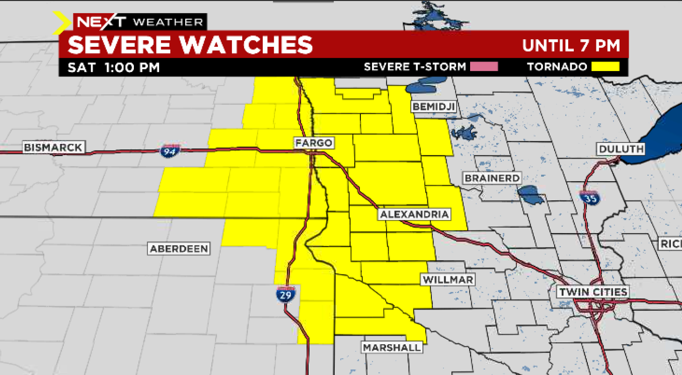
UPDATE (12:53 p.m.) - A tornado watch has been issued for parts of northwestern Minnesota, including Becker, Big Stone, Chippewa, Clay, Clearwater, Douglas, Grant, Hubbard, Lac qui Parle, Mahnomen, Norman, Otter Tail, Polk, Red Lake, Stevens, Swift, Todd, Traverse, Wadena, and Wilkin County until 7 p.m.
UPDATE (11 a.m.) - A flash flood warning has been issued for Grand Forks and Polk County until 7:45 p.m. on Saturday.
UPDATE (8:15 a.m.) -- A severe thunderstorm warning has been issued for parts of Blue Earth, Le Sueur, and Waseca counties until 8:30 a.m. The storm is heading northeast, and if it holds together, could make it to Bloomington and Richfield around 9 a.m.
MINNEAPOLIS (WCCO) -- It's already been plenty wet and rainy this week so far, but another system could bring damaging storms on Saturday, which is why we're calling a Next Weather Alert day for Saturday.
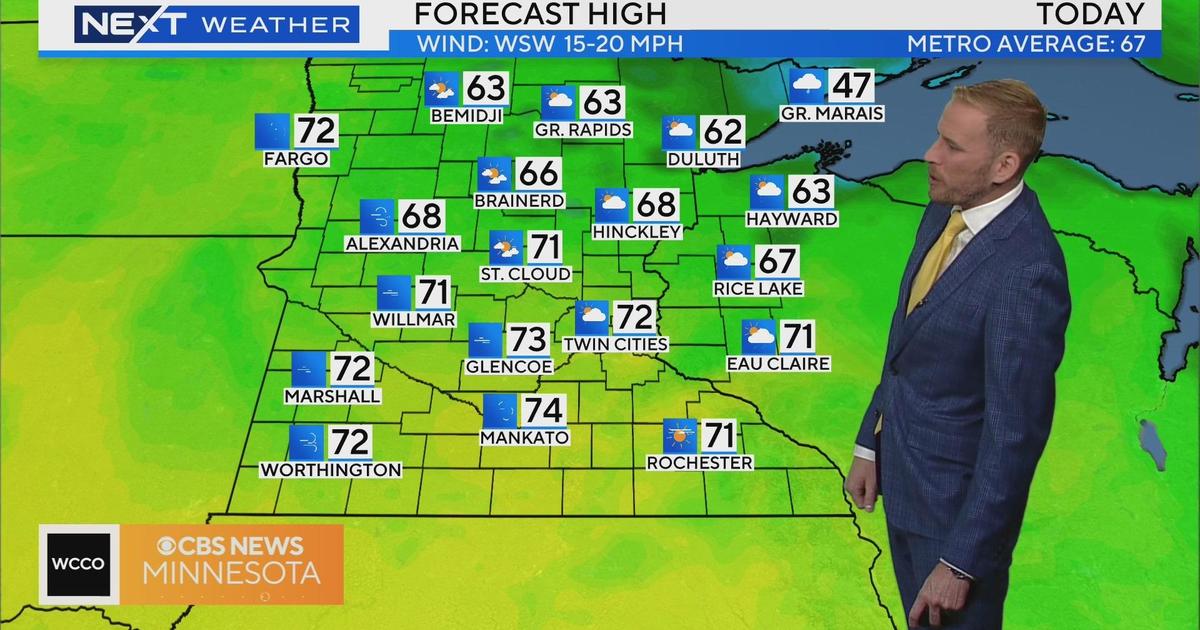
The potential for some real rumbles begins on Saturday. The day will be much warmer and highs will reach into the 70s, and it'll be quite humid.
Storms will move through the Twin Cities metro quickly until 11 a.m. Then there will be a break - though it'll still be windy - before the main round of scattered severe thunderstorms makes its way through in the afternoon.
The biggest threat for the area comes in the form of potentially damaging hail. There's also a possibility for wind gusts exceeding 50 mph in the southwest portion of the state Saturday. Deep in the southwest corner - from Marshall to Worthington - there is a potential for brush fires to start.
There's also a flood warning due to a large amount of snow melt in northwestern Minnesota, from Bemidji to Fargo. Also in northern Minnesota, there is a possibility of tornadoes briefly spinning up areas including Bemidji, Alexandria, and Brainerd.
By around 10 p.m. on Saturday evening, the severe weather threat will likely expire.
Next Week
Cooler weather arrives Sunday into next week, and the pattern stays fairly quiet.
That being said, there's still a likelihood that the next week brings temperatures mostly below average for this time of year. Monday's high is looking to stall out in the low 40s, with overnight lows early next week hovering around or even below freezing.
Those seeking the comforting rays of sunshine will also find that much of next week is looking more cloudy than not. Once again, April is breaking hearts in Minnesota.