Next Weather Alert: Flash Flood Warnings, Large Hail In SE Minnesota
MINNEAPOLIS (WCCO) -- Supercell thunderstorms rumbled Thursday evening over southern Minnesota and western Wisconsin, dropping hail across the area. Get the latest updates below:
Update (10:05 p.m.) - A flash flood warning has been issued for parts of Winona County until 2 a.m. Friday.
The warning area extends from Elba to Goodview. Residents are encouraged to stay on higher ground and not drive through flood waters.
Update (8:40 p.m.) - A severe thunderstorm warning has been issued for parts of Houston and Winona counties until 9:15 p.m.
Radar shows the storm line tracking toward the towns of Dakota, La Crescent and Brownsville. Threats include quarter-sized hail and wind gusts up to 60 mph.
Update (8:33 p.m.) - A severe thunderstorm warning is in effect for parts of La Crosse, Vernon and Monroe counties in western Wisconsin until 9 p.m.
Radar shows the storm line moving toward the cities of La Crosse, St. Joseph and Coon Valley. Threats include quarter-sized hail and wind gusts up to 60 mph.
Update (7:59 p.m.) -- A severe thunderstorm warning has been issued for Winona County until 8:45 p.m.
Radar shows the storms are tracking toward the towns of Wyattville, Wilson and Dakota. Threats include half-dollar-sized hail and 60 mph wind gusts.
Update (7:52 p.m.) -- A severe thunderstorm warning has been issued for Houston County until 8:30 p.m.
Radar shows the storm cell moving towards the towns Norway, Houston, and La Crosse, Wisconsin. Forecasters say the threats include quarter-sized hail, wind gusts up to 60 mph and possible tornadoes.
Update (6:50 p.m.) -- No severe thunderstorm warnings are currently in effect. Forecasters say the storms continue to shift eastward, and the severe weather threat is diminishing. However, it is possible that supercell storms develop over southeastern Minnesota in the late evening hours.
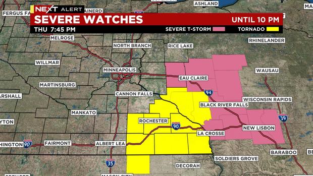
Update (6:35 p.m.) - The National Weather Service has removed several counties -- including those that make up the Twin Cities metro -- from the severe thunderstorm watch that was issued earlier in the afternoon. Still, a tornado watch remains in effect for much of south-central and southeastern Minnesota until 10 p.m.
Update (6:14 p.m.) - A severe thunderstorm warning has extended to parts of Freeborn and Steele counties until 6:45 p.m.
Radar shows a storm cell moving toward Blooming Prairie. Threats include golf-ball-sized hail and wind gusts up to 60 mph.
Update (6:09 p.m.) - A severe thunderstorm warning has been issued for parts of Dodge and Olmsted counties until 6:45 p.m.
Radar shows the storm cell tracking towards the cities of Kasson, Rochester and Zumbro. Threats include quarter-sized hail and wing gusts up to 60 mph.
Update (6:07 p.m.) - A severe thunderstorm warning has been issued for parts of Freeborn and Steele counties until 6:30 p.m.
Radar shows the storm cell is tracking towards the towns of Geneva and Blooming Prairie. Threats include quarter-sized hail and wind gusts up to 60 mph.
Update (6:01 p.m.) - A severe thunderstorm warning remains in effect for parts of Faribault and Freeborn counties until 6:15 p.m.
The storm cell is tracking towards the towns of Freeborn, Alden, and Manchester. Threats include quarter-sized hail and wind gusts up to 60 mph.
Update (5:49 p.m.) - A severe thunderstorm warning has been issued for an area of Pierce County in western Wisconsin until 6:15 p.m.
Radar shows the storm cell tracking towards the towns of Rock Elm and Elmwood. Threats include golf-ball-sized hail and wind gusts up to 60 mph.
Update (5:40 p.m.) - A severe thunderstorm warning remains in effect for parts of Faribault, Freeborn, Steele and Waseca counties until 6:15 p.m.
Radar shows the storm cell tracking towards the cities of Wells, Freeborn, Hartland, New Richland, and Geneva. Threats include quarter-sized hail and wind gusts up to 60 mph.
Update (5:26 p.m.) - A severe thunderstorm warning remains in effect for parts of Waseca and Steele counties until 5:45 p.m.
The storm is tracking toward the cities of New Richland and Otisco. Threats include quarter-sized hail and wind gusts up to 60 mph.
Update (5:22 p.m.) - A severe thunderstorm warning is in effect for parts of Faribault and Freeborn counties until 5:45 p.m.
Cities in the storm line's path include Frost, Wells, Alden, and Freeborn. Threats include quarter-sized hail and wind gusts up to 60 mph.
Update (5:07 p.m.) - A severe thunderstorm warning has been issued for parts of Dakota and Rice counties until 5:30 p.m.
Forecasters say the storm line is moving toward the towns of Northfield, Randolph, Hampton, and Vermillion. Threats include quarter-sized hail and wind gusts up to 60 mph.
Meanwhile, a severe thunderstorm warning has also been issued for parts of Dunn County in western Wisconsin until 6:15. Towns in this storm cell's path include Eau Claire, Chippewa Falls, Fall Creek, and Wilson.
Update (5:02 p.m.) - A severe thunderstorm warning has been issued for parts of Blue Earth, Faribault and Waseca counties until 5:30 p.m.
Forecasters say the storm line is moving toward the cities of Delavan, Minnesota Lake, Waldorf, and Matawan. Threats include quarter-sized hail and wind gusts up to 60 mph.
Update (4:57 p.m.) - A severe thunderstorm warning continues for Dunn County is western Wisconsin until 5:15 p.m. Forecasters say this supercell storm has a history of creating large hail.
Update (4:43 p.m.) - A severe thunderstorm warning has been issued for an area of Dakota County until 5 p.m.
Cities in the storm cell's path include Farmington, Rosemount, Vermillion, and Hastings. Forecasters say the storm threatens quarter-sized hail and wind gusts up to 60 mph.
Update (4:37 p.m.) -- A severe thunderstorm warning has been issued for parts of Barron, Dunn, Pierce, and St. Croix counties in western Wisconsin until 5:15 p.m.
Radar shows the severe storm line moving toward the towns of Baldwin, Menomonie, and Elk Mound. Forecasters say threats include ping-pong-sized hail and wind gusts up to 60 mph.
Update (4:29 p.m.) - A severe thunderstorm warning is in effect for parts of Dakota, Rice and Scott counties until 4:45 p.m.
The severe storm cell is moving toward to the cities of Northfield, Castle Rock and Lakeville. Forecasters say threats include quarter-sized hail, 60+ mph wind gusts and possible tornadoes.
Update (4:19 p.m.) - A severe thunderstorm warning was issued for parts of Chippewa, Dunn, and Eau Claire counties in western Wisconsin until 5 p.m.
Forecasters say the storm cell is moving toward the cities of Eau Claire, Chippewa Falls, and Stanley. Threats include quarter-sized hail, 60+ mph wind gusts and possible tornadoes.
Update (4 p.m.) - A severe thunderstorm warning in Washington County has been extended until 4:45 p.m., while one has been issued for Goodhue County until 4:30 p.m.
Polk and St. Croix counties in Wisconsin are also under a severe thunderstorm warning through the same time.
Update (3:40 p.m.) - Dakota, Hennepin, Ramsey and Washington counties are under a severe thunderstorm warning until 4:15 p.m.
Hail was falling in downtown and northeast Minneapolis, as well as St. Paul, as the storm moved through:
Update (3:15 p.m.) - A tornado watch has been issued in Blue Earth, Brown, Dodge, Faribault, Fillmore, Freeborn, Goodhue, Houston, Le Sueur, Martin, Mower, Nicollet, Olmsted, Rice, Sibley, Steele, Wabasha, Waseca, Watonwan and Winona counties until 10 p.m.
The following counties are under a severe thunderstorm watch until 10 p.m.: Anoka, Carver, Chisago, Dakota, Hennepin, Isanti, McLeod, Ramsey, Scott, Sherburne, Washington and Wright.
Buffalo and Pepin counties in Wisconsin are also under a tornado watch.
Update (1:40 p.m.) - Severe thunderstorm warnings have been issued in Fillmore, Olmsted, and Winona counties until 2:30 p.m.
Update (1:20 p.m.) - Severe thunderstorm warnings have been issued for Dodge, Olmsted, Wabasha, and Winona counties until 2 p.m.
Update (12:45 p.m.) - A severe thunderstorm warning has been issued for Fillmore and Mower counties until 1:45 p.m.
MINNEAPOLIS (WCCO) -- Thursday is a Next Weather Alert day due to storms that are on track to fire in south-central and southeastern Minnesota in the afternoon and evening.
As of midday Thursday, a severe thunderstorm is pushing through the southern edge of Minnesota, producing golf ball-to-tennis ball size hail. The storm, which will stay south of Interstate 90, is moving to the east.
After a quiet period in the afternoon, the threat for severe weather picks up again around 3 p.m., with the highest chance for storms between 5 p.m. and 6 p.m. The threat should subside by 10 p.m., WCCO Next Weather Meteorologist Mike Augustyniak says.
There is an enhanced risk for severe storms in the south and southeast portions of the state, with mainly damaging hail followed by possible wind damage. A tornado can't be ruled out.
The Twin Cities metro area is in a slight severe weather risk.
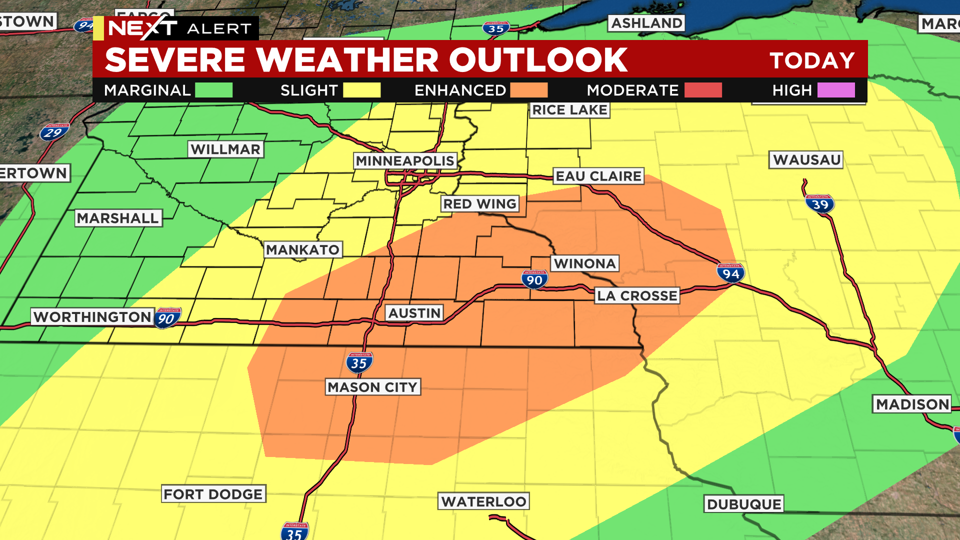
After 3 p.m., some isolated supercell thunderstorms that could produce destructive weather will move through southeastern Minnesota. There's a chance those storms could impact areas southeast of the Twin Cities around 7 p.m.
At the same time, another thunderstorm scenario could play out in Alexandria.
Then after 9 p.m., the fuel for the storms will run out, and widespread rain will move through the rest of central Minnesota.
Thursday's high in the metro will reach into the 70s, but Friday's high will be about 10 degrees cooler, and Saturday will be about 10 degrees cooler than that, with some isolated showers possible. The weekend will be cool indeed, with highs stalling in the 50s. Some areas of the state could even see patchy frost early on Sunday.
The extended forecast doesn't feature a major warm-up, with temperatures expected to remain below average for this time of year.