Minnesota Weather: Isolated Thunderstorms, Weak Tornadoes Possible Thursday In Southeast MN
MINNEAPOLIS (WCCO) - After tornadoes touched down across southern Minnesota on Wednesday evening, Thursday could again see isolated thunderstorms with the possibility of tornadoes.
The National Weather Service confirmed eight tornadoes touched down across Owatonna, Morristown, Henderson, Dundas, and Elko New Market on Wednesday between 7:25 p.m. and 8:25 p.m., though the damage was minimal.
The rain on Thursday moved from the Twin Cities up towards western Wisconsin and the Boundary Waters. Off to the west, however, a spinning low pressure system and a cool front is developing near Thief River Falls.
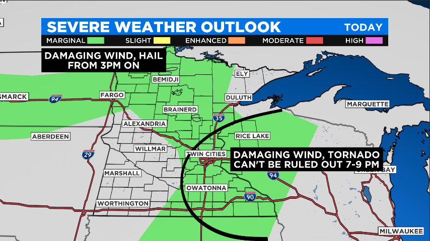
The NWS says there is a marginal risk for severe weather Thursday, with isolated thunderstorms on the way for the afternoon in both northwestern and southeastern Minnesota.
Northwestern Minnesota could see damaging wind gusts after 3 p.m., with hail the size of nickels and quarters.
East of the metro area however, tornadoes could develop between 7 p.m. and 9 p.m. These tornadoes would be brief and could cause low-end damage. After that, some non-severe thunderstorm activity will continue through the night.
Friday, temperatures will reach the low-80s throughout most of the state, and on Saturday the temperatures will reach near-90 degrees. Afterwards, a cool front will move in, bringing the temperatures down in the early part of next week.