Minnesota Weather: 1 Dead, NWS Confirms 3 Tornadoes Touched Down Across MN
UPDATE (9 a.m. Saturday): The National Weather Service confirmed an additional tornado touched down in Le Sueur County, bringing the total up to three.
The tornado in Le Sueur County, as well as the ones in Burnsville and Apple Valley, have been rated EF-0s, with winds up to 85 mph.
UPDATE (5:30 p.m.): The National Weather Service has confirmed that two tornadoes touched down during the overnight storm.
NWS reports there was one tornado in northeast Burnsville near Highway 13 and Cliff Road, and another in Apple Valley near Highway 77 and 145th Street.
So far, no EF rating has been given.
UPDATE (5 p.m.): As of 4 p.m., Xcel Energey reported that there were 19,000 customers still without power in Minnesota and Wisconsin. The company said that 89,000 customers have had their power restored.
Work will be most intensive along the Minnesota river and over to Hudson, including the southern and eastern suburbs of the Twin Cities.
UPDATE (12 p.m.): As of noon, Xcel Energy reported that there were still more than 30,000 customers without power in the Twin Cities metro and western Wisconsin. That's down from a peak of around 80,000 households without power earlier in the morning.
The utility says that it has nearly 400 employees and contractors working quickly to restore service.
The storms that swept over Minnesota in the early morning hours brought powerful winds, with gusts of more than 60 mph. The gusts knocked over power lines and toppled trees, causing power outages and damage to yards, cars and houses.
In Mankato, a tree branch fell on a tent, fatally wounding a 4-year-old girl inside. She died at an area hospital shortly thereafter.
A number of schools in the metro area canceled, delayed or moved classes online due to electrical outages and tree branches blocking roadways.
Across the St. Croix River, in Hudson, Wisconsin, the city's public library sustained substantial damage after debris from a nearby roof blew into the building, breaking through the lobby windows.
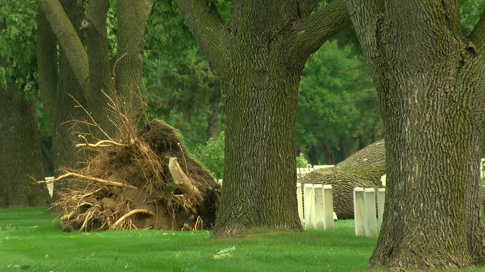
In Minneapolis, the storm damage extended to Fort Snelling National Cemetery. Debris littered the grounds and several large trees planted amid the headstones were uprooted.
UPDATE (11 a.m.): Officials in Mankato say a 4-year-old girl died Friday morning after a tree branch fell on the tent she was in overnight.
The Mankato Department of Public Safety says that officers responded to an injury call at Land of Memories Park around 2:30 a.m., just as squall line storms were moving across southern Minnesota.
At the scene, officers found a 4-year-old girl with life-threatening injuries and tried to aid her. An ambulance brought her to a local hospital, where she was later pronounced dead.
No one else in the tent was harmed.
UPDATE (10:30 a.m.) The squall line storms that lashed the Twin Cities early Friday morning with strong winds toppled a number of trees at Fort Snelling National Cemetery.
Images posted on social media show a line of tall trees uprooted amid the gravestones in the Minneapolis cemetery, where more than 246,000 are buried.
Meanwhile, Xcel Energy says that roughly 37,000 customers remain without power in metro area and western Wisconsin.
UPDATE (8 a.m.): Thousands of residents in the Twin Cities metro and western Wisconsin woke up Friday to power outages after a line of blustery storms tore through the area, uprooting trees and knocking over power lines.
Stay Informed: WCCO Weather App | Radars | Weather Page
According to Xcel Energy, crews are still working to restore power to more than 60,000 customers across the metro area, particularly in the south. Earlier in the morning, more than 80,000 households were without power.
The outages and reports of downed trees blocking roadways have prompted a number of schools in the east and south metro to cancel, delay or move classes online. In Hudson, Wisconsin, all area schools were closed Friday, as the district said that six of its eight schools were without electricity.
RELATED: School Closings Page
Storm damage has been reported across the Twin Cities and western Wisconsin. One building that sustained significant damage was the Hudson Public Library, where the windows were blown out by debris from the roof a nearby building. The library is closed as cleanup gets underway.

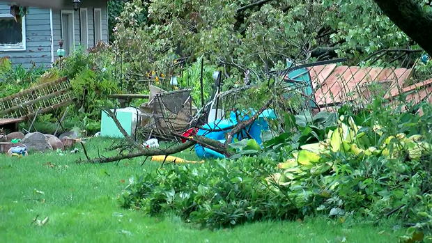
In the south metro, crews were out before sunrise clearing streets of debris, mostly from fallen trees. A WCCO-TV crew in Burnsville saw yards with large trees uprooted, weather-resistant fences destroyed and one trampoline flipped up-side down.
So far, no injuries have been reported.
The squall line of storms hit the Twin Cities around 3 a.m., bringing strong winds, small hail and later heavy downpours. At Minneapolis-St. Paul International Airport, a wind gust of 64 mph was recorded. Another unconfirmed report listed a gust in Bloomington at 73 mph, just before the threshold for hurricane-force winds.
In the wake of the storms, skies are expected to clear throughout the day, leading to a sunny afternoon with mild temperatures in the low 70s.
UPDATE (6:30 a.m.): A line of severe storms swept over the Twin Cities metro early Friday morning, leaving many downed trees and thousands without power.
As of writing, Xcel Energy is reporting that more than 70,000 customers across the metro and western Wisconsin are without power, particularly in the south metro. The utility says crews are working to restore service.
Forecaster Katie Steiner says the storms lashed the area shortly before 4 a.m. with wind gusts as strong as 64 mph. Hail and heavy downpours were also reported in the early morning hours.
Officials in Burnsville, Eagan, Savage, and Apple Valley said they were all working to deal with the damage, most of which was downed trees. Indeed, a Burnsville official said that city trucks were being used to remove the debris, some of which were blocking roadways.
Neighbors in Eagan reported incredibly loud sounds, saying they'd "never heard anything that loud."
"Like a rolling sound came through here," said Mike Herr. He said branches fell onto his garage and into his boat, blocking him in.
So far, there have been no immediate reports of injuries or trees damaging homes.
Still, a WCCO-TV crew found many uprooted trees throughout the south metro. Residents in one Burnsville neighborhood near Echo Drive woke up to trees on top of cars, felled fencing, and, in one case, a trampoline flipped upside-down.
Damage was also reported in western Wisconsin, where the windows were blown out at the Hudson Public Library. Images posted online showed the building's lobby and children's area filled with storm debris. In a Facebook post, officials said that the library is closed due to the storm damage.
On the Minnesota side of the border in Stillwater, the start of classes was delayed at a number of area schools. (For school closing information, click here.)
According to Steiner, the storm system weaken significantly as it moved eastward into Wisconsin.
In the wake of the storms, skies over Minnesota are expected to clear throughout the day, making for a sunny afternoon with temperatures in the low 70s.
UPDATE (10:30 p.m.): Parts of Minnesota saw impressive rain totals Thursday night, and more is on the way in the overnight hours.
As storms moved eastward through the state, they brought heavy wind and hail along with the rainfall.
More heavy rainfall will enter the state around 2 a.m., hitting the Twin Cities just before 5 a.m. That wave of storms will bring thunder and lightning, but likely nothing more severe.
Friday will be calm and comfortable, with a high of 72. Summer-like temperatures will return over the weekend.
UPDATE (8 p.m.): There are no active tornado warnings in Minnesota, though a tornado watch remains in effect in several northern Minnesota counties until midnight.
A line of storms is crawling east through central and northern Minnesota, bringing heavy rain, wind and hail. The severe weather threat will start to die out as the night goes on, but there will still be active thunderstorms, including heavy rain in the Twin Cities, through the overnight hours.
UPDATE (7:05 p.m.): A tornado warning for Morrison and Mille Lacs counties has been extended until 7:30 p.m.
Meanwhile, several northern Minnesota counties are under a tornado watch until midnight. The affected counties are Aitkin, Carlton, Crow Wing, Kanabec, Lake, Mille Lacs, Morrison, Pine, St. Louis and Todd.
St. Louis County is under a severe thunderstorm warning until 7:45 p.m.
UPDATE (6:40 p.m.): A tornado warning is in effect in Morrison and Mille Lacs counties until 7:15 p.m.
An earlier tornado warning for Todd County has expired.
Additionally, severe thunderstorm warnings are in effect in Chippewa, Lac qui Parle, Renville and Yellow Medicine counties until 7:15 p.m.
UPDATE (5:55 p.m.): A tornado warning has been issued for Morrison and Todd counties in central Minnesota.
The warning is in effect until 6:30 p.m.
Additionally, several northern Minnesota counties are under a tornado watch until midnight. The affected counties are Aitkin, Carlton, Crow Wing, Kanabec, Lake, Mille Lacs, Morrison, Pine, St. Louis and Todd.
Aitkin and Crow Wing are also under severe thunderstorm warnings until 6:30 p.m.
MINNEAPOLIS (WCCO) -- While Thursday will mostly be sunny, warm and breezy, storms are expected to develop in the evening hours, and some could turn severe overnight.
The National Weather Service says much of Minnesota, including the western half of the Twin Cities, has a slight chance of experiencing severe weather over the next 24 hours. The main threats will be large hail and damaging winds, although isolated tornadoes can't be ruled out.
Stay Informed: WCCO Weather App | Live Radars | Weather Page
Weather officials are encouraging Minnesotans to be weather aware Thursday night, especially if planning to be outdoors.
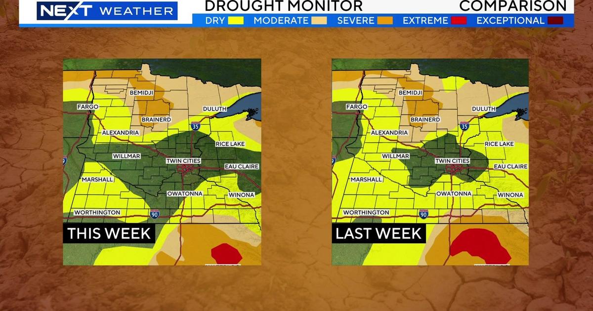
According to forecaster Katie Steiner, storms and showers will first develop over northern Minnesota Thursday evening, bringing much-needed rain to the drought-stricken area.
Initially, the threat up north could be damaging winds, hail, and an isolated tornado. But as the evening progresses, more storms will fire along a cold front in the north and west.
Later, more storms will develop to the south, but the threat will diminish to a slight risk for severe storms in the western part of the metro.
By sunrise, most of the system will have moved into western Wisconsin, making way for a clear, cool day.
The cool weather won't last too long, however, as a surge of summer weather is in store for the weekend. Sunday's temperatures are expected to reach the upper 80s, and the heat looks to last into the start of the workweek.