Minnesota Weather: Temperatures Expected To Climb Above Avg. Next Week
RESOURCES: School Closings | Live Radar | Weather App
MINNEAPOLIS (WCCO) - The weather watcher is red as Sunday will be slightly warmer than Saturday.
This comes after the first major snowstorm of the season, with over 19 inches of snowfall reported in the Twin Cities.
In the east metro, a band of snow fell at about 2 inches an hour for several hours. According to WCCO's Weather Watcher Network, the highest snowfall totals of 18-19.5 inches were recorded in Woodbury, Belle Plaine and Bloomington. Eagan reported 15 inches, with 14 inches tabulated in Farmington.
Areas to the north missed out on the major snow, with Little Falls reporting 1 inch. But down near Maple Grove, Weather Watchers reported 4.5 inches, with over 9 inches reported in Chanhassen, St. Paul, and Edina. South of the metro, there was still between 7 and 9 inches of accumulation. Meteorologist Mike Augustyniak reports a 15 inch range in snowfall totals in 45 miles across the metro area.
However, as temperatures start to get warmer, snow will be melting into next week. Meteorologist Lisa Meadows says a warming trend will start on Sunday.

With the snow melt, fog could come Sunday night into Monday. Starting next week, temperatures are expected to climb well above average. Wednesday is expected to be a record warm day, but there is a slight chance of rain overnight. Cooler temperatures roll in next weekend.
Road Conditions, Crashes
According to the Minnesota State Patrol, there were 321 crashes, 311 vehicles off-road, and 21 jackknifed semis statewide between 6 a.m. Friday and noon on Saturday. In those incidents, 26 people were injured, and one person died in an alcohol-involved crash.
Cities Declare Snow Emergencies
Minneapolis and St. Paul were among cities that declared snow emergencies. Be careful of parking on the street; Day 1 rules in Minneapolis began on Friday. That means that plows have cleared emergency routes, and will begin working on the even side of the streets on Saturday. St. Paul crews will start plowing Day Routes starting Saturday morning.
As for the suburbs, snow emergencies have been declared in Crystal, St. Louis Park, New Hope, Eden Prairie, Richfield, and Brooklyn Park, among other cities. (For more information on snow emergency rules in Minnesota, click here.)
Snow In Minnesota, Tornadoes In Central U.S.
Saturday's snow wasn't the only big weather-related event. The parent storm system from Minnesota's storm is in western Wisconsin and headed for Chicago. But it created a massive severe weather outbreak in the middle part of the country with over 70 feared to be dead in Kentucky.
Tornado watches and warnings were posted in nine states from Texas to the Great Lakes, and the NWS is working to determine if a single tornado ripped its way over 200 miles, which if true, would be the longest-track tornado ever recorded in the U.S.
The Next Big Weather-Maker
The warmup will continue into Wednesday, when it could hit 50 degrees in the evening. Rain could develop in the later hours of the afternoon, with a potential for thunderstorms. The storms shouldn't be severe, and will instead switch us back to colder temperatures.
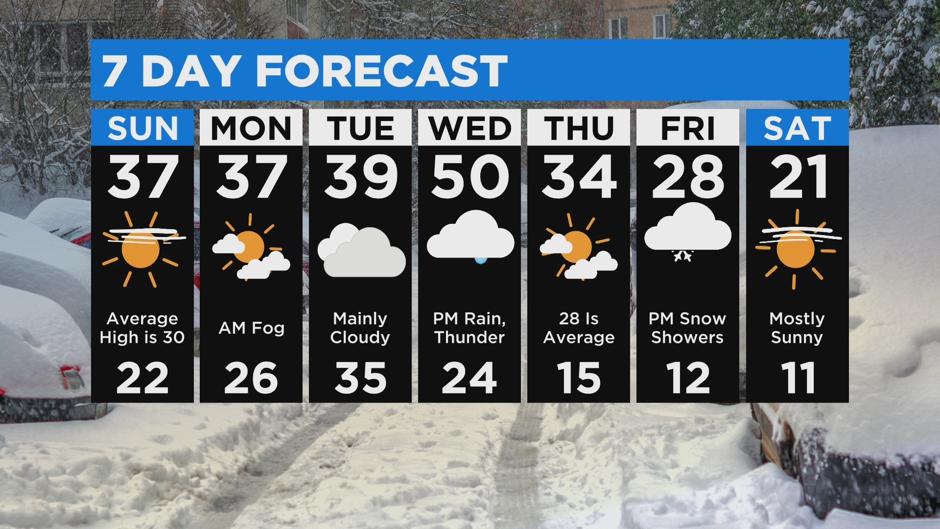
The warmup means that a white Christmas still isn't guaranteed. Outside of the major accumulation in the eastern suburbs, there's a chance that all of the snow could melt by Thursday.
For context, the average high temperature for mid-December in the Twin Cities is in the mid-20s. The average low is about 12 degrees.